| << Lerntafeln Rechnen und Schreiben - PRESSOGRAM << Lerntafeln Mathematik |
  | |
Zuletzt angesehene Artikel:
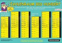
![]() | Zahlenraum bis 100 PRESSOGRAM Zaubertafel Rechnen im Zahlenraum 2. Klasse PRODESIGN Lernspiel GmbH |
![]() | 038 Aberdeen, Inverurie & Pitmedden - Wanderkarte Großbritannien 1:50.000 Active Laminiert LANDRANGER MAP - Ordnance Survey |
![]() | Istanbul - touristischer Stadtplan und Reiseführer (türk./engl./dt.) Touristmap Istanbul Harita ve Rehberi Mepmedya Türkei |
![]() | 5521 Gedern Topographische Landkarte Hessen 1:25.000 - ProjektNord (geplottete Ausgabe) |
![]() | Isle Royale National Park - MI (Blatt: 240) Landkarte Trails Illustrated Map National Geographic - USA |
![]() | Nordost-Island (Blatt 3) - Touristische Landkarte 1:250.000 Norðausturland ferðakort 3 Landmælingar - Island |
![]() | 15-13 Vrbno pod Pradedem Topographische Karte 1:50.000 der Tschechischen Republik Zakladnà mapa Ceská republika - Cesky urad zememericky a katastralni - ProjektNord |
![]() | Climbing the Peaks of Central Alborz (Blatt 321) Panoramakarte نقشه صعود به قله هاي البرز مركزي Gitashenasi - Iran |
![]() | Finale 51 - Rock climbing a Finale Ligure Kletterführer - Andrea Gallo - IDEE VERTICALI Rock climbing a Finale Ligure |
![]() | Zahlenraum bis 10.000 + 100.000 PRESSOGRAM Zaubertafel Rechnen im Zahlenraum 4. Klasse PRODESIGN Lernspiel GmbH |
![]() | 17 Paffenwinkel - Ostallgäu - - Landsberg am Lech - Füssen - Fünfseenland und Werdenfelser Land Freizeitkarte 1:100.000 (ATK100) Amtliche topographische Karte Bayern - Landesamt für Vermessung und Geoinformation Bayern |
![]() | 193.13 Amtliche topographische Karte 1:25.000 Polen |
![]() | Innere Fränkische Schweiz (Blatt 3) Spezialkarte 1:35.000, GPS-tauglich, Rad- und Wanderwege, Freizeiteinrichtungen, Sehenswürdigkeiten, Archäologie Appelt-Verlag |
![]() | 3119 Vilsen Amtliche topographische Karte 1:25.000 Landesvermessungsamt Niedersachsen |
![]() | 1272 Topographische Karte 1:25.000 Messtischblatt des Deutschen Reiches - Preußische Landesaufnahme / Reichsamt für Landesaufnahme - Faksimile ProjektNord |
![]() | 1069 (12-46) Chiclana de la Frontera Amtliche topographische Landkarte 1:50.000 Spanien (M.T.N.) 1069 Mapa Topográfico Nacional de Espana (MTN50) Instituto Geográfico Nacional - CNIG Spanien |
![]() | Italie - Voyage en train 1:1.550 Mio. Landkarte Cartotrain |
![]() | Falk Cityplan Stuttgart 1:21.000 |
![]() | The Way of St Benedict Wanderführer (englisch) - Frignani S. - TERRE DI MEZZO |
![]() | Havelseen 3 Rad-, Wander- und Gewässerkarte - wasserfest 1:35.000 - Grünes Herz |


