Willkommen bei MapFox
+++ Buchhändleranfragen willkommen! Tel. 0431-666 75 99 +++
Warenkorb
Artikel: 0 - € 0.00
Zur Kasse
Impressum Kontakt Versandkosten AGB
Mathe Magie - Rechnen bis 100 PRESSOGRAM Zaubertafel Mathematik PRODESIGN Lernspiel GmbH
<< Lerntafeln Rechnen und Schreiben - PRESSOGRAM
<< Lerntafeln Mathematik
 
Cover

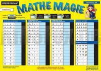
Spielerisches Üben und Lernen der Grundrechnungsarten: Multiplikation, Division, Addition und Subtraktion, Lernentwicklung durch ansteigende Schwierigkeitsgrade, Motivation durch sofortige Selbstkontrolle, Alle Zaubertafeln sind doppelseitig bedruckt, abwischbar und immer wieder verwendbar. Als Zauberstift kann jeder handelsübliche abwaschbare Filzstift verwendet werden.

Mathe Magie - Rechnen bis 100 PRESSOGRAM Zaubertafel Mathematik PRODESIGN Lernspiel GmbH
EAN / ISBN: 4260107040613
Preis: EUR 4.95

sofort versandfertig Dieser Artikel ist im Normalfall sofort lieferbar.
Produkt EUR Anzahl Bestellen
Mathe Magie - Rechnen bis 100 PRESSOGRAM Zaubertafel Mathematik PRODESIGN Lernspiel GmbH 4.95
Versandkostenfrei in Deutschland ab 30,- Bestellwert

incl. MwSt.

Stichworte, die bei der Suche nützlich sein könnten:
Lerntafel Mathematik - PRESSOGRAM - Lerntafeln - Pressogram - Zaubertafeln - Lerntafeln - Zaubertafeln - Lerntafeln - Lerntafeln Rechnen - Lerntafeln Mathematik - Handkarten - Laminierte Lernkarten - Lerntafeln Mathematikunterricht

Zuletzt angesehene Artikel:

CoverMathe Magie - Rechnen bis 100 PRESSOGRAM Zaubertafel Mathematik PRODESIGN Lernspiel GmbH

Cover570 Pereiras-Gare (Odemira) Topographische Landkarte Portugal 1:25.000 Carta Militar de Portugal - Série M888 Instituto Geográfico do Exército (IGeoE) - Portugal

Noch kein Cover vorhanden57 Hekla SV Topographische Karte Island 1:50.000 - Ferdakort
57 HEKLA SV - Atlaskort - Sérkort

Cover5827 Maßbach Topographische Landkarte Bayern 1:25.000 - Normalausgabe - ProjektNord (geplottete Ausgabe) - Grundlage amtliche Topographische Karte Bayern DTK25

Cover5214 Burbach (geplottete Ausgabe) Amtliche topographische Karte 1:25.000 Landesvermessungsamt Nordrhein-Westfalen

CoverL2318 Bad Bederkesa (geplottete Ausgabe) Topographische Karte 1:50.000 Kartografie Landesvermessungsamt Niedersachsen - ProjektNord

Cover2834 Gorlosen Sonderausgabe mit Wanderwegen - Topographische Wanderkarte Brandenburg 1:25.000 ProjektNord

CoverSobrepuerto: Pelopin - Manchoya - Cancias - Oturia - Wanderkarte - MTB bicycle map&guide Pirineo Aragones - 1:40.000 - Spanien - Wanderkarte (spanisch) ALPINA

Cover22 Lake District & Cumbria Cycle Map 1:100.000 Features sections of the C2C Route, Hadrians Cycleway, Way of the Roses plus all other NCN Routes - Cycle Maps UK - Lovell Johns

Cover5631 Meeder Topographische Landkarte Bayern 1:25.000 - Normalausgabe - ProjektNord (geplottete Ausgabe) - Grundlage amtliche Topographische Karte Bayern DTK25

Cover172 Südliche Umgebung Pressburg - Donautiefland - Neusiedlersee - Hainburg Fahrradkarte Slowakei 1:60.000
Okolie Bratislavy juh - Podunajská nížina - SHOCart

CoverCERVERA DEL MAESTRAT - CÀLIG - Baix Maestrat 1:20.000 Wanderkarte - Editorial Piolet - Spanien

CoverUnstrut Radwanderweg 1:50.000 (Peter Leischner) Radwanderführer mit Kartenausschnitten Grünes Herz

Cover8427 Immenstadt Allgäu Topographische Landkarte Bayern 1:25.000 - Normalausgabe - ProjektNord (geplottete Ausgabe) - Grundlage amtliche Topographische Karte Bayern DTK25

CoverP5132 Riistavesi Topographische Karte 1:25.000 EUREF (Peruskartta) Maanmittauslaitos / Lantmäteriverket Finnland - ProjektNord

CoverDUMONT Reise-Taschenbuch Lanzarote von Reisenegger, Verónica

CoverMasone - Campo Ligure - Rossiglione e Tiglieto e Urbe - Provincia di Genova (Blatt GE-8) Topographische Wanderkarte 1:25.000
Carta dei Sentieri EdM - Edizioni del Magistero - Italien

CoverKurpien - Grüne Wildnis - Równina Kurpiowska - unteres Narew-Tal 1:100.000 - Touristische Landkarte und Wanderkarte Polen
Kurpie - Puszcza Zielona - Równina Kurpiowska - Dolina Dolnej Narwi Agencja TD - Polen

CoverL3318 Sulingen (geplottete Ausgabe) Topographische Karte 1:50.000 Kartografie Landesvermessungsamt Niedersachsen - ProjektNord

CoverDinslaken - Hünxe - Kirchheller Heide Topographische Wanderkarte Nordrhein-Westfalen mit Wanderwegen und Radwegen 1:25.000 - ProjektNord