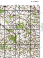
| << Polen: Amtliche topographische Landkarten 1:100.000 << Polen: Amtliche Topographische Landkarten 1:100.000 im Regelblattschnitt, Faksimile-Druck von ProjektNord (mit Qualitätsverlust) |
  | |
Zuletzt angesehene Artikel:
![]() | M-34-63/64 Krakow, Katowice (Krakau - Kattowitz) Plot aus der Kartengrundlage der amtliche topographische Karte Polen 1:100.000 ProjektNord |
![]() | M-34-8-A/B Garwolin Amtliche topographische Landkarte Polen 1:50.000 M-34-8-A/B Garwolin - Mapa Topograficzna Polski Glowny Geodeta Kraju |
![]() | 5412 Selters (Westerwald) - Wanderkarte mit Wanderwegen (geplottete Ausgabe) ProjektNord - Grundlage Amtliche topographische Karte Landesamt für Vermessung und Geobasisinformation Rheinland-Pfalz |
![]() | Ausgewählte Vögel und Säugetiere von Spitzbergen LaminierteFaltkarte - Frank S. Todd Selected Birds & Mammals of Svalbard - by Frank S. Todd Ecocepts International |
![]() | M441 Sysmä Topographische Karte 1:50.000 EUREF-FIN (Maastokarttat) Maanmittauslaitos / Lantmäteriverket Finnland - ProjektNord |
![]() | La Vienne à pied - 36 promenades & randonnées Poitou-Charentes - Réf. D086 Topographischer Wanderführer - FFRP (Fédération française de randonnée pédestre) Frankreich |
![]() | Chor - Flusskarte 1:60.000 Reka Hor Karta-shema / Хор Dal`newostochnyj Federal`nyj Okrug - Russland |
![]() | 25108 Piz Corvatsch - Serie Gipfel 1:25.000 Piz Nair - St. Moritz - Piz Bernina - Topographische Wanderkarte der Schweiz - swisstopo |
![]() | Tschechisch-Österreichische Grenze MTB-Radtourführer Fernradwege Cyklopruvodce Cesko-rakouské pohranici - Dalkova cyklotrasa SHOCart - Tschechien |
![]() | Peloponnes - Landkarte und Touristenführer Regionale Landkarte 1:250.000 Orama - Griechenland Πελοπόννησος - Peloponnese - Map & Guide |
![]() | 1078 Kleine Karpaten - Pressburg Wanderkarte Slowakei 1:50.000 Malé Karpaty - Bratislava SHOCart |
![]() | K422 Inkoo Topographische Karte 1:50.000 EUREF-FIN (Maastokarttat) Maanmittauslaitos / Lantmäteriverket Finnland - ProjektNord |
![]() | Radrouten und Grüne Wege in Frankreich 1:1 Mio. Landkarte (Blatt 779) Véloroues et voies vertes en France Michelin |
![]() | Bükk - Topographische Wanderkarte 1:40.000 Szarvas Térképek Ungarn Bükk - Bükkalja - Heves-Borsodi-dombság - Upponyi-ség |
![]() | Deutschland - Autoatlas 1:200.000 Mit Kartenteil Alpenbogen 1:500.000 und 50 Traumrouten - Freytag-Berndt und ARTARIA |
![]() | Historische Karte: ÄRMELKANAL - Südliches ENGLAND und nördliches FRANKREICH - KANALINSELN - um 1710 - Historische Landkarte Tabula nova complectens Praefecturas Normanniae et Britanniae, una cum Angliae, parte et Manica cum Privil. Ord. Gen. Belgii Foederati - von Visscher, Nicolaes (Kartogr.) Schenk, Peter der Jüngere - Verlag Rockstuhl |
![]() | La ligne bleue des Vosges - Déodatie et Vologne - Réf. 0880 Topographischer Wanderführer - FFRP (Fédération française de randonnée pédestre) Frankreich |
![]() | M514 Saimaa Topographische Karte 1:50.000 EUREF-FIN (Maastokarttat) Maanmittauslaitos / Lantmäteriverket Finnland - ProjektNord |
![]() | Tour du Beaujolais des Pierres Dorées + 20 jours de randonnée - Réf. 6900 Topographischer Wanderführer - FFRP (Fédération française de randonnée pédestre) Frankreich |
![]() | Les portes de Cornouaille 1:50.000 - Réf. TC015 Topographische Wanderkarte - FFRP (Fédération française de randonnée pédestre) Frankreich |


