| << WeiÃrussland: Wanderkarten << Polen: Wanderkarten: Ostpolen << PTOP - Polen |
||
|
||


Zuletzt angesehene Artikel:
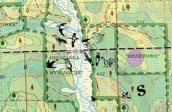
 | Bialowieza-Urwald (WeiÃrussischer Teil) 1:50.000 naturkundliche Landkarte Belawetschskaja Puschtscha - Puszcza Bialowieska - PTOP |
 | 3822 11+08 Rihtatsobma Topographische Karte 1:20.000 (Maastokartta / Peruskartta / Grundkarta) Maanmittauslaitos / Lantmäteriverket Finnland - ProjektNord |
 | 1370 Glowitz Topographische Karte 1:25.000 Messtischblatt des Deutschen Reiches - PreuÃische Landesaufnahme / Reichsamt für Landesaufnahme - Faksimile ProjektNord |
 | 4616 Olsberg (geplottete Ausgabe) Amtliche topographische Karte 1:25.000 Landesvermessungsamt Nordrhein-Westfalen |
 | 941-1 LOS LABRADOS Amtliche topographische Landkarte 1:25.000 Spanien (M.T.N.) 941-1 Mapa Topográfico Nacional de Espana (MTN25) Instituto Geográfico Nacional - CNIG Spanien |
| 1321 Jörl - Gestern und Heute - Historische Ãberlagerung 1878-1880 Topographische Landkarte 1:25.000 im Vergleich - Landesvermessungsamt Schleswig-Holstein / ProjektNord |
| M-34-23-C/D Urszulin Amtliche topographische Landkarte Polen 1:50.000 M-34-23-C/D Urszulin - Mapa Topograficzna Polski Glowny Geodeta Kraju |
 | Mit dem Wohnmobil nach Polen (Band 62) Der Süden. Schlesien, Krakau, Hohe Tara, Karpaten. Tipps, Tricks, Touren, Tolle Plätze. Alle Plätze mit präzisen GPS-Daten. Die Anleitung für einen Erlebnisurlaub - von Helmut Breidenbach und Angelika Breidenbach - Womo |
| 1720 Heide Nord - Gestern und Heute - Historische Ãberlagerung 1878-1880 Topographische Landkarte 1:25.000 im Vergleich - Landesvermessungsamt Schleswig-Holstein / ProjektNord |
 | X521 Nuorgam Topographische Karte 1:50.000 EUREF-FIN (Maastokarttat) Maanmittauslaitos / Lantmäteriverket Finnland - ProjektNord |
 | 742-3 LA RODA Amtliche topographische Landkarte 1:25.000 Spanien (M.T.N.) 742-3 Mapa Topográfico Nacional de Espana (MTN25) Instituto Geográfico Nacional - CNIG Spanien |
 | N531 Savonlinna Topographische Karte 1:50.000 EUREF-FIN (Maastokarttat) Maanmittauslaitos / Lantmäteriverket Finnland - ProjektNord |
 | 0769 NAVARRÃS Topographische Landkarte 1:50.000 Spanien (Grundlage MTN50) Instituto Geográfico Nacional - CNIG Spanien - ProjektNord |
 | Oblast Riwne / Rowno 1:250.000 Landkarte, StraÃenkarte - Ukraine Riwnenska oblast / Рівненська область Карта автошляхів Kartografija - ukrmap Ukraine |
 | 4519 Marsberg (geplottete Ausgabe) Amtliche topographische Karte 1:25.000 Landesvermessungsamt Nordrhein-Westfalen |
 | Val Fontanabuona - Monte di Portofino - Rapallo - Provincia di Genova (Blatt GE-2) Carta dei Sentieri Topographische Wanderkarte 1:25.000 EdM - Edizioni del Magistero - Italien |
 | 4312 Hamm (geplottete Ausgabe) Amtliche topographische Karte 1:25.000 Landesvermessungsamt Nordrhein-Westfalen |
 | 4712 08 Ruuvaoja Topographische Karte 1:20.000 (Maastokartta / Peruskartta / Grundkarta) Maanmittauslaitos / Lantmäteriverket Finnland - ProjektNord |
 | 0806-4 CABEZA DEL BUEY Topographische Landkarte 1:25.000 Spanien (Grundlage MTN25) Instituto Geográfico Nacional - CNIG Spanien - ProjektNord |
 | N433 Kangasniemi Topographische Karte 1:50.000 EUREF-FIN (Maastokarttat) Maanmittauslaitos / Lantmäteriverket Finnland / ProjektNord |