Willkommen bei MapFox
Wurde Ihre Bestellung bestätigt? Wenn nicht - gab es evtl. ein SERVER-Problem! Bitte kontaktieren Sie uns! +++ Buchhändler-Anfragen erwünscht +++
Warenkorb
Artikel: 0 - € 0.00
Zur Kasse
Impressum Kontakt Versandkosten AGB
Tongariro Circuit & Round the Mountain Track 1:40.000 + Track Guide Wanderkarte - Neuseeland Geographx - Craig Potton Publishing Neuseeland
<< Neuseeland
<< Potton & Burton / Craig Potton Publishing
 
Cover

Established in 1887, Tongariro was the first national park in New Zealand and the fourth in the world. It is also a dual World Heritage area, a status which recognises the park`s important Maori cultural and spiritual associations as well as its outstanding volcanic features.

It is a place of extremes and surprises, a place to explore and remember. From herb fields to forests, from tranquil lakes to desert-like plateau and active volcanoes - Tongariro has them all.
Tongariro National Park is located in the central North Island of New Zealand. It is the closest national park to Auckland, New Zealands largest city, and is very accessible from State Highway 1. The nearest towns are Turangi, National Park and Ohakune.

Features:

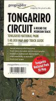
- Additional Tongariro National Park 3D Map on reverse
- Award-winning relief mapping
- Track notes, elevation and distance graphic
- Printed on waterproof, tear-resistant, environmentally sustainable `Rockstock` paper.

Kartenbeispiel aus der Serie

Mit zusätzlicher Panoramakarte der weiteren Umgebung

Kartenausschnitt

Tongariro Circuit & Round the Mountain Track 1:40.000 + Track Guide Wanderkarte - Neuseeland Geographx - Craig Potton Publishing Neuseeland
EAN / ISBN: 9416458075407
Preis: EUR 24.90

Dieser Titel ist momentan nicht lieferbar.
Produkt EUR Anzahl Bestellen
Tongariro Circuit & Round the Mountain Track 1:40.000 + Track Guide Wanderkarte - Neuseeland Geographx - Craig Potton Publishing Neuseeland 24.90
Versandkostenfrei in Deutschland ab 30,- Bestellwert

incl. MwSt.

Stichworte, die bei der Suche nützlich sein könnten:
Neuseeland Wanderkarte - Tongariro Circuit - New Zealand - Neuseeland - Mount Ruapehu - Tongariro Nationalpark - Tongariro National Park - Neuseeland - Neuseeland Wanderkarten - Neuseeland Karten - Neuseeland Radwanderführer - Neuseeland Kartographie - Neuseeland Landkarten - Neuseeland Fahrradkarten - Neuseelandkarten - Neuseeland Atlanten - Neuseeland Landkartenverkauf - Neuseeland Reiseführer - Neuseeland Straßenkarten - Neuseeland Kartografie - Neuseeland Radwanderkarten - New Zealand - New Zealand Radwanderkarten - New Zealand Kartographie - New Zealand Landkarten - New Zealand Straßenkarten - New Zealand Fahrradkarten - New Zealandkarten - New Zealand Reiseführer - New Zealand Radwanderführer - New Zealand Kartografie - New Zealand Atlanten - New Zealand Landkartenverkauf - New Zealand Wanderkarten - New Zealand Karten - Neuseeland Wanderkarten - Neuseland Wanderführer - Neuseeland Trekkingführer - New Zealand - Neuseeland - Craig Potton Publishing - Craig Potton Landkarten - Craig Potton Trekkingkarten - Neuseeland Nationalpark-Karten - Neuseeland Karten - Neuseeland Wandern - New Zealand hiking maps - New Zealand trekking - New Zealand national parks

Zuletzt angesehene Artikel:

CoverTongariro Circuit & Round the Mountain Track 1:40.000 + Track Guide Wanderkarte - Neuseeland Geographx - Craig Potton Publishing Neuseeland

Cover0615ET MORLAIX - PLESTIN-LES-GREVES Topographische Wanderkarte Frankreich 1:25.000 TOP 25 IGN - (GPS)

Noch kein Cover vorhanden24-d Topographische Landkarte Georgien 1:50.000 Geoland Maps Georgien

CoverDingle Peninsula Superwalker XT30 Wanderkarte 1:30.000 - Including Dingle Way - Harvey maps Großbritannien

Noch kein Cover vorhanden43-b Topographische Landkarte Georgien 1:50.000 Geoland Maps Georgien

CoverNew England - Hudson Valley Regionale Straßenkarte 1:500.000 (Blatt 581) Michelin

CoverSavona Stadtplan 1:10.000
Savona - Pianta della Citta L.A.C. GlobalMap Italien

Cover40 LE LEMAN 1:100.000 Topographische Landeskarte der Schweiz - swisstopo

CoverUSA 1 Nordwest 1:750.000 Landkarte Reise-Know-How Verlag - world mapping project

CoverLippe Gewässerkarten Regional 1: 75.000 - Jübermann Wassersportkarte

CoverTriest 1:8.000 Stadtplan City pocket
Trieste Touring-Club Italiano (TCI) Italien

CoverPicardie - Baie de Somme - LeGuideVert - Grüner Reiseführer (französisch) - Michelin

Cover134 Veporske Vrchy Wanderkarte Slowakei 1:50.000 - VKU

Noch kein Cover vorhanden2312ET CLERMONT - CREIL Topographische Wanderkarte Frankreich 1:25.000 TOP 25 IGN - (GPS)

Noch kein Cover vorhanden33-a Topographische Landkarte Georgien 1:50.000 Geoland Maps Georgien

CoverBayerische Alpen - Wandern am Wasser - Bergseen · Schluchten · Wildbäche - Bergverlag Rother

Noch kein Cover vorhanden2435OT MONTS DU CANTAL Topographische Wanderkarte Frankreich 1:25.000 TOP 25 IGN

CoverADAC BundesländerKarte 8 Thüringen 1:250.000

CoverSeattle 1:10.000 *** SCHNÄPPCHEN *** Stadtplan Borch laminiert

CoverChateaux de la Loire Reiseführer LeGuideVert - Grüner Reiseführer (französisch) Michelin