Willkommen bei MapFox
Wurde Ihre Bestellung bestätigt? Wenn nicht - gab es evtl. ein SERVER-Problem! Bitte kontaktieren Sie uns! +++ Buchhändler-Anfragen erwünscht +++
Warenkorb
Artikel: 0 - € 0.00
Zur Kasse
Impressum Kontakt Versandkosten AGB
Grenze USA - Kanada 1:2.5 Mio. Landkarte
US Canada Border Travel Reference Map ITMB International Travel Maps (engl.)
<< USA
<< Kanada
<< ITMB - International Travel Maps
 
Cover

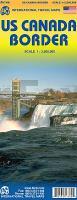
The Canadian/US border is the longest single border in the world between two countries. It stretches from the southern end of Vancouver Island eastward to Nova Scotia/New Brunswick, has dozens upon dozens of border crossings and stretches for about 5,000 kilometers - or is it miles? Regardless, it is long, but more importantly, since 1815, it has been promoted as the longest `undefended` border in the world. Naturally, there is a strict border patrol/surveillance on both sides of the border area, but there are no troops, no navy, no air force operations on either side. It is unprecedented in world history to have such a long border, free of military supervision. This map is double-sided and shows the border states and their provincial counterparts, starting with British Columbia and Washington/Idaho/Montana for about 150 miles on either side of the actual border, and carries on eastward through the Prairie/Midwest region, before dipping south to encircle the Great Lakes region, before terminating with New York City at the southern extreme and most of New Brunswick/Maine in the northeast. The purpose of the map is to show the true nature of a region where more than 100,000,000 people live; the highways binding them together, the major cities as insets (Long Island, Boston region, Chicago,Toronto central, Seattle, Vancouver, and Victoria), the many border crossings and the artificiality of the border. This is a map showing how easy it is to travel from North Dakota to Manitoba (for instance), or how easy it is to make a Great Lakes round trip.

Kartenausschnitt

Kartenbeispiel

Grenze USA - Kanada 1:2.5 Mio. Landkarte
US Canada Border Travel Reference Map ITMB International Travel Maps (engl.)
EAN / ISBN: 9781553417385
Preis: EUR 11.90

sofort versandfertig Dieser Artikel ist im Normalfall sofort lieferbar.
Produkt EUR Anzahl Bestellen
Grenze USA - Kanada 1:2.5 Mio. Landkarte
US Canada Border Travel Reference Map ITMB International Travel Maps (engl.)
11.90
Versandkostenfrei in Deutschland ab 30,- Bestellwert

incl. MwSt.

Stichworte, die bei der Suche nützlich sein könnten:
USA - United States of America - Vereinigte Staaten von Amerika - Vereinigte Staaten von Amerika - United States - USA - U.S.A. - Kanada - Canada maps - Canada Landkarten - Kanada Landkarten - Kanada Reiseführer - Kanada Fahrradkarten - Kanadakarten - Kanada Radwanderführer - Kanada Kartographie - Kanada Atlanten - Kanada Karten - Kanada Wanderkarten - Kanada Straßenkarten - Kanada Kartografie - Kanada Radwanderkarten - Kanada Landkartenverkauf - ITMB - ITM - International Travel Maps - ITMB Internationale Landkarten - ITB-Karten - ITMB-Karten - International Travel Maps and Books

Zuletzt angesehene Artikel:

CoverGrenze USA - Kanada 1:2.5 Mio. Landkarte
US Canada Border Travel Reference Map ITMB International Travel Maps (engl.)

CoverTrekking in Austria`s Hohe Tauern - Venediger, Glockner and Reichen Groups - Wanderführer Österreich - Cicerone (englisch)

CoverUtö & Ornö 1:20 000 - Stigkarta - Wanderkarte Schweden - Calazo Förlag

CoverThe Cleveland Way and the Yorkshire Wolds Way With the Tabular Hills Walk - Wanderführer - Cicerone Großbritannien (englisch)

CoverLolland Topographische Karte Dänemark 1:100.000 - Kort & Matrikelstyrelsen ProjektNord

Cover2837OT LAC D`ISSARLES/THUEYTS Topographische Wanderkarte Frankreich 1:25.000 TOP 25 IGN

CoverLe Tour pédestre de l`Île-de-France de gare en gare en 30 étapes Wanderführer RANDO EDITIONS

CoverFischkarte Ostböhmen 1:200.000
Východní Cechy - rybárska mapa - SHOCart - Tschechien

Cover800 Jahre Hassee Vom Bauerndorf zum Kieler Stadtteil - Geschichtskreis Rund um den Russee e.V. - Carsten Frahm Verlag Kiel

Noch kein Cover vorhanden3447-SO Topographische Karte 1:10.000 - Landesvermessungsamt Brandenburg

CoverRendsburg - Wittensee Topographische Wanderkarte mit Wanderwegen und Radwegen 1:25.000 Schleswig-Holstein - ProjektNord

CoverAREA 5: Maule y Bio Bio - Regionale Landkarte 1:400.000
5 Mapa Turístico: Maule y Bío Bío Mapas Compass Chile

Cover13 Mecklenburg-Vorpommern Autokarte + Freizeitkarte 1:200.000 freytag & berndt

CoverEngland Südost - Midlands - East Anglia Regionale Straßenkarte 1:400.000 (Blatt 504) Michelin Großbritannien

Cover67 Langisjor Topographische Karte Island 1:100.000 - Ferdakort
67 LANGISJÓR - Atlaskort - Ferðakort

Cover67 Ostrava (Ostrau) Wanderkarte Tschechien 1:50.000
Ostravsko - SHOCart

CoverIsar-Radweg 1:75.000 Von Scharnitz zur Donau - bikeline Radwanderführer - Esterbauer

CoverKarvina 1:15.000 Stadtplan
Karviná a Okoli SHOCart Tschechien

CoverThe Islands of Croatia - 30 Walking Routes on 14 Adriatic islands Wanderführer (englisch) Cicerone Großbritannien

Noch kein Cover vorhandenC7926 Neu-Ulm Topographische Karte 1:100.000 - Bayrisches Landesvermessungsamt