Willkommen bei MapFox
Wurde Ihre Bestellung bestätigt? Wenn nicht - gab es evtl. ein SERVER-Problem! Bitte kontaktieren Sie uns! +++ Buchhändler-Anfragen erwünscht +++
Warenkorb
Artikel: 0 - € 0.00
Zur Kasse
Widerruf Impressum Kontakt Versandkosten AGB
Yorkshire 3 Peaks Challenge Map - Super-Durable Map Wanderkarte (wasserfest) Discovery Walking Guides Ltd
<< Großbritannien: Wanderkarten, Radwanderkarten und MTB-Karten
<< Discovery Walking Guides Ltd.
 
Cover

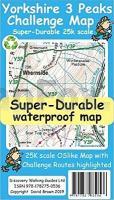
Yorkshire 3 Peaks Challenge Map at 25k scale with challenge routes highlighted. OS 50k scale mapping is doubled in size to produce a 25k map but the features, text and logos are now doubled in size making them much easier to read under challenge conditions. Y3P 12 Hour Challenge Route, and its options for ascending Whernside, are added and specially highlighted so that the route stands out against the OS background map. Then we add any additional detail you might need including the popular Challenge starting points of the Pen Y Ghent Cafe, Station Inn and Hill Inn. On the reverse of the map sheet are the Challenge and OS Legends, cover design, and an access map (approx 60k scale) for road access from the nearest towns of Ingleton and Settle. The result is a double sided 600mm by 600mm OSlike Super-Durable Map. We then print the map design on a 100 micron plastic substrate using a special UV curing inks process on the UK`s only press capable of using this latest technology. The result is a lightweight map that is both waterproof and tearproof, and fully recyclable, that will survive anything your 3 Peaks Challenge can throw at it and afterwards will fold up like new.

Kartenausschnitt

Kartenbeispiel

Yorkshire 3 Peaks Challenge Map - Super-Durable Map Wanderkarte (wasserfest) Discovery Walking Guides Ltd
EAN / ISBN: 9781782750765
Preis: EUR 11.90

Bestellartikel: versandfertig in ca. 1-3 Wochen. Dieser Artikel wird speziell für Sie bestellt. Keine Rücknahme!
Produkt EUR Anzahl Bestellen
Yorkshire 3 Peaks Challenge Map - Super-Durable Map Wanderkarte (wasserfest) Discovery Walking Guides Ltd 11.90
Versandkostenfrei in Deutschland ab 30,- Bestellwert

incl. MwSt.

Stichworte, die bei der Suche nützlich sein könnten:
Yorkshire Wanderkarte - Discovery Walking Guides - Kanarische Inseln Wanderkarten - Madeira Wanderkarten - Großbritannien Wanderkarten - Großbritannien Fahrradkarten - Großbritannien Mountainbike-Karten

Zuletzt angesehene Artikel:

CoverYorkshire 3 Peaks Challenge Map - Super-Durable Map Wanderkarte (wasserfest) Discovery Walking Guides Ltd

Cover255 Llangollen & Berwyn - Wanderkarte Großbritannien 1:25.000 EXPLORER MAP - Active Map LAMINIERT - Ordnance Survey

CoverBitburger Land 4 Topographische Wanderkarte Rheinland-Pfalz mit Wanderwegen und Radwegen 1:25.000 - ProjektNord

CoverEuropa: physisch 1:7.5 Mio. Format: ca. 100 x 70 cm Westermann Schulbuchverlag

CoverProvence - Cote d`Azur Regionale Straßenkarte 1:200.000 (Blatt 527) Michelin Frankreich

CoverMallorca 1:35.000 - 4 Wanderkarten im SET mit Broschüre (Nr. 2230) KOMPASS

CoverMadagassisch - Wort für Wort Kauderwelsch-Sprachführer (Band 041) Madagaskar - Reise-Know-How Verlag

CoverBrügge 1:11.500 Stadtplan Belgien
Bruges Michelin

Cover16 Gesenke - Touristische Landkarte Tschechien 1:100.000
Jeseníky - Turistická mapa KARTOGRAFIE PRAHA

CoverLos Angeles city puzzle magnets 100 Teile - City Puzzle Extragoods

Cover60/7-8 BERTOGNE - LONGVILLY NGI 1:25.000 Topographische Landkarte Belgien

CoverSierra de las Nieves - 2 Topographische Wanderkarten + Guide 1:25:000 CNIG Spanien

Noch kein Cover vorhanden12-b Topographische Landkarte Georgien 1:50.000 Geoland Maps Georgien

Noch kein Cover vorhandenCC 4702 Düsseldorf Bodenübersichtskarte 1:200.000 - Bundesanstalt für Geowissenschaften und Rohstoffe (BGR)

CoverMARCO POLO Reisekarte Frankreich 1:950.000

CoverFalster Topographische Karte Dänemark 1:100.000 - Kort & Matrikelstyrelsen ProjektNord

CoverGävle - Sandviken & Hofors 1:50.000 Terrängkartan Calazo Förlag Schweden

CoverSouthern Upland Way - Scotland`s coast to coast trail Wanderführer - Cicerone (englisch)

CoverBükk Atlas 1:40.000 Wanderatlas Ungarn (ungarisch) - Cartographia

CoverCanyoning in Samothraki - Griechische Inseln - Anavasi / Griechischer Canyoning Verband - Griechenland