Willkommen bei MapFox
Wurde Ihre Bestellung bestätigt? Wenn nicht - gab es evtl. ein SERVER-Problem! Bitte kontaktieren Sie uns! +++ Buchhändler-Anfragen erwünscht +++
Warenkorb
Artikel: 0 - € 0.00
Zur Kasse
Widerruf Impressum Kontakt Versandkosten AGB
Assynt & Coigach - British Mountain Map 1:40.000 Superwalker - BMC - HARVEY MAPS - Großbritannien
<< Großbritannien: Wanderkarten, Radwanderkarten und MTB-Karten
<< Harvey Maps
 
Cover

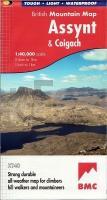
This map shows the spectacular sandstone peaks of Assynt at 1:40,000 scale on one sheet. Includes Quinag, Suilven, Stac Pollaidh, Cul Mor and Ben More Assynt.
The map area includes 2 Munros, 9 Corbetts and 6 Grahams.
Enlargements at 1:15,000 scale of Stac Pollaidh, Suilven and Quinag on the reverse. Also a Geological map of Assynt
Printed on polyethylene - durable, tear-resistant and 100% waterproof. Made in cooperation with the British Mountaineering Council and the Mountaineering Council of Scotland
Colour shading for easy identification of hills and valleys. Climbing crags are highlighted and a climbing route on Stac Pollaidh is included. Less than half the weight of a laminated map

Assynt & Coigach - British Mountain Map 1:40.000 Superwalker - BMC - HARVEY MAPS - Großbritannien
EAN / ISBN: 9781851376278
Preis: EUR 28.90

Bestellartikel: versandfertig in ca. 3-7 Tagen. Dieser Artikel wird speziell für Sie bestellt. Keine Rücknahme!
Produkt EUR Anzahl Bestellen
Assynt & Coigach - British Mountain Map 1:40.000 Superwalker - BMC - HARVEY MAPS - Großbritannien 28.90
Versandkostenfrei in Deutschland ab 30,- Bestellwert

incl. MwSt.

Stichworte, die bei der Suche nützlich sein könnten:
British Mountain - Assynt - Assynt Wanderkarte - Assynt Mountainbike-Karte - British Mountain Mountainbike-Karte - British Mountain Wanderkarte - Großbritannien Wanderkarten - Großbritannien Fahrradkarten - Großbritannien Mountainbike-Karten - Harvey maps - Superwalker - Schottland Wanderkarten - Großbritannien Wanderkarten - Harvay - Harway Maps - Britsh Mountain Maps - BMC - Ultramaps - XT40 - XT25 - Great Britain walking maps - UK hiking maps - Scotland hiking maps - Harveymaps - UK Walking maps - Great Britain walking maps

Zuletzt angesehene Artikel:

CoverAssynt & Coigach - British Mountain Map 1:40.000 Superwalker - BMC - HARVEY MAPS - Großbritannien

CoverWashington Road & Recreation Atlas 1:200.000-1:600.000 - Benchmark Atlas USA

Cover14 Biggesee - Südsauerland 1:25.000 Topographische Wanderkarte - GeoMap

CoverVictoria planning map Planungskarte (engl.) Lonely Planet

CoverOldenburg 1978 (Blatt 167) Historischer Bildstadtplan Bollmann-Bildkarten-Verlag

CoverBaedeker Reiseführer Thailand MAIRDUMONT

Cover3 in 1 City Map Basel 1:16.000 Map, Travel information, Highlights, Sightseeing, Index

CoverSettle to Carlisle Way - Wanderkarte 1:40.000 Long Distance Route - HARVEY MAPS

CoverFinnland Süd 1:500.000 Landkarte Reise-Know-How Verlag - world mapping project

CoverNeuseeland 1:800.000 Wolfgang Kunth Verlag

CoverCharlotte Street Map, NC Stadtplan - Rand McNally - USA

CoverRom und Vatikan 1:15.000 - laminierter Stadtplan comfort!map
Rome and The Vatican ExpressMap