Willkommen bei MapFox
Wurde Ihre Bestellung bestätigt? Wenn nicht - gab es evtl. ein SERVER-Problem! Bitte kontaktieren Sie uns! +++ Buchhändler-Anfragen erwünscht +++
Warenkorb
Artikel: 0 - € 0.00
Zur Kasse
Widerruf Impressum Kontakt Versandkosten AGB
Walking Offa`s Dyke Path: Route Map Booklet 1:25.000 Wanderkarten-Broschüre Schottland - Cicerone Großbritannien (englisch)
<< Großbritannien: Wanderführer + Kletterführer
<< Cicerone
 
Cover

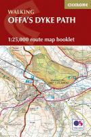
Map of the 177 mile (283km) Offa`s Dyke Path National Trail, between Sedbury (near Chepstow) and Prestatyn. The trail takes 2 weeks to walk, and is suitable for walkers at all levels of experience. This compact booklet of OS 1:25,000 maps shows the full route, providing all of the mapping you need, and is included with the guidebook.

Kartenausschnitt

Kartenbeispiel

Walking Offa`s Dyke Path: Route Map Booklet 1:25.000 Wanderkarten-Broschüre Schottland - Cicerone Großbritannien (englisch)
EAN / ISBN: 9781852848941
Preis: EUR 19.90

Bestellartikel: versandfertig in ca. 3-7 Tagen. Dieser Artikel wird speziell für Sie bestellt. Keine Rücknahme!
Produkt EUR Anzahl Bestellen
Walking Offa`s Dyke Path: Route Map Booklet 1:25.000 Wanderkarten-Broschüre Schottland - Cicerone Großbritannien (englisch) 19.90
Versandkostenfrei in Deutschland ab 30,- Bestellwert

incl. MwSt.

Stichworte, die bei der Suche nützlich sein könnten:
Offas Dyke Path - Offa`s Dyke Path Wanderführer - Großbritannien - Großbritannien Wanderführer - Großbritannien Trekkingführer - Großbritannien Klettern - Großbritannien Kletterführer - Cicerone - Cicerone Radwanderführer - Cicerone Wanderführer - Großbritannien Radwanderführer - Großbritannien Wanderführer - Cicerone Großbritannien

Zuletzt angesehene Artikel:

CoverWalking Offa`s Dyke Path: Route Map Booklet 1:25.000 Wanderkarten-Broschüre Schottland - Cicerone Großbritannien (englisch)

CoverSlowakisches Paradies - Wanderkarte 1:50.000 (Blatt 404)
SŁOWACKI RAJ Cartomedia - Sygnatura

CoverFlat Tops NE (Blatt: 122) Landkarte Trails Illustrated Map National Geographic - USA

CoverFrankreich Luftfahrtkarte OACI Südost 1:500.000 (aktuelle Ausgabe) IGN - Frankreich

CoverHerzstoß Roman. Psychothriller. Übersetzung: Lutze, Kristian - von Joy Fielding - Goldmann

CoverPesaro - Urbino Stadtplan 1:8.000/1:6.500
Pesaro - Urbino - Pianta della Citta L.A.C. GlobalMap Italien

CoverWintersportkarte Riesengebirge 1:60.000
Krkonose Riesengebirge - Zimni turisticka a lyzarská mapa SHOCart - Tschechien

Cover6204 Langsur Topographische Karte 1:25.000 - Landesamt für Vermessung und Geobasisinformation Rheinland-Pfalz

Cover5603 Wischeid Topographische Karte 1:25.000 - Landesamt für Vermessung und Geobasisinformation Rheinland-Pfalz

Cover5606 Üxheim Topographische Karte 1:25.000 - Landesamt für Vermessung und Geobasisinformation Rheinland-Pfalz

CoverSchottland Regionale Straßenkarte 1:400.000 (Blatt 501) Michelin Großbritannien

Cover5612 Bad Ems Topographische Karte 1:25.000 - Landesamt für Vermessung und Geobasisinformation Rheinland-Pfalz

Cover356 Kintyre South - Wanderkarte Großbritannien 1:25.000 EXPLORER MAP - Active Map LAMINIERT - Ordnance Survey

Cover6511 Landstuhl Topographische Karte 1:25.000 - Landesamt für Vermessung und Geobasisinformation Rheinland-Pfalz

CoverReichensteiner Gebirge Wanderkarte Polen 1:35.000
Góry Złote - Rychlebské hory Compass - Polen

Cover5512 Montabaur Topographische Karte 1:25.000 - Landesamt für Vermessung und Geobasisinformation Rheinland-Pfalz

CoverSüdafrika - Lesotho, Swasiland 1:2.1 Mio.
SOUTH AFRICA - Lesotho, Swaziland - Internationale Landkarte - Cartographia

Cover2417OT FORET DE FONTAINEBLEAU Topographische Wanderkarte Frankreich 1:25.000 TOP 25 IGN - (GPS)

Cover6413 Winnweiler Topographische Karte 1:25.000 - Landesamt für Vermessung und Geobasisinformation Rheinland-Pfalz

Cover09 La Via dei Campioni 1:25.000 - Monte Colma - Frazione Ricciotti - Rad- und Wanderkarte - Ingenia Editori - Italien
Carta cicloescursionistica del tratto compreso tra Monte Colma e Frazione Ricciotti sulla Via dei Campioni