| << Historische Deutschlandkarten << Rockstuhl |
||
|
||

Zuletzt angesehene Artikel:
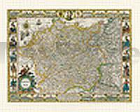
 | Deutschland - Germania, 1607 - Historische Landkarte Nachdruck Planokarte - gerollt von Hondius, Jacobus - Verlag Rockstuhl |
 | 0646-4 CALA EN PORTER Topographische Landkarte 1:25.000 Spanien (Grundlage MTN25) Instituto Geográfico Nacional - CNIG Spanien - ProjektNord |
 | N511 Juva Topographische Karte 1:50.000 EUREF-FIN (Maastokarttat) Maanmittauslaitos / Lantmäteriverket Finnland - ProjektNord |
 | 0170-2 LAGRAN Topographische Landkarte 1:25.000 Spanien (Grundlage MTN25) Instituto Geográfico Nacional - CNIG Spanien - ProjektNord |
 | Auf dem Jakobsweg durch Böhmen, das Österreichische Mühlviertel und Südostbayern nach Innsbruck (Band: 294) von Reinhard Dippelreither OutdoorHandbuch - Conrad-Stein-Verlag |
 | Wanderkarte Ferienwelt Winterberg 1:25.000 Winterberg Touristik und Wirtschaft GmbH - mr-kartographie - Grünes Herz |
 | 1083-1 SANTO DOMINGO Topographische Landkarte 1:25.000 Spanien (Grundlage MTN25) Instituto Geográfico Nacional - CNIG Spanien - ProjektNord |
 | 155 hantada Amtliche topographische Landkarte 1:50.000 Spanien (M.T.N.) 155 Mapa Topográfico Nacional de Espana (MTN50) Instituto Geográfico Nacional - CNIG Spanien |
 | Tatra-Vorland: Podhale - Spisz - Orawa Touristische Landkarte und Wanderkarte Polen 1:50.000 (Blatt 403) Sygnatura - Cartomedia - Polen |
 | Hellenthal - Kall - Schleiden - Topographische Wanderkarte 1:25.000 (Blatt 14) Offizielle Wanderkarte des Eifelvereins - Kartengrundlage Landesvermessungsamt Rheinland-Pfalz |