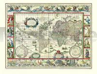
| << Rockstuhl |
  | |
Zuletzt angesehene Artikel:
![]() | Historische WELTKARTE 1635 - Willem Janszoon Blaeu - Historische Landkarte Originalinschrift der World Map: Nova Totius Terrarum Orbis Geographica Ac Hydrographica Tabula | Weltkarten Vol. 1 - von Willem Janszoon Blaeu - PLANO gerollt - Verlag Rockstuhl |
![]() | L6732 Schwabach (gedruckte Ausgabe) Topographische Karte Bayern 1:50.000 Bayerisches Landesvermessungsamt |
![]() | 22-112 Topographische Karte 1:25.000 der Tschechischen Republik Zakladní mapa Ceská republika Cesky urad zememericky a katastralni - ProjektNord |
![]() | 26-13 Topographische Karte 1:50.000 der Tschechischen Republik Zakladní mapa Ceská republika - Cesky urad zememericky a katastralni - ProjektNord |
![]() | M5134 Imatra Topographische Karte 1:25.000 EUREF (Peruskartta) Maanmittauslaitos / Lantmäteriverket Finnland - ProjektNord |
![]() | 0377-2 VALDENARROS Topographische Landkarte 1:25.000 Spanien (Grundlage MTN25) Instituto Geográfico Nacional - CNIG Spanien - ProjektNord |
![]() | Mit dem Wohnmobil nach Süd-Schweden (Band 54) Tipps, Tricks, Touren, Tolle Plätze. Alle Plätze mit präzisen GPS-Daten. Die Anleitung für einen Erlebnisurlaub - von Reinhard Schulz und Waltraud Roth-Schulz - WOMO-Verlag |
![]() | Top Touren in Jämtland Skitourenführer schwedisch Toppturer i Jämtland Calazo Förlag Schweden |
![]() | 0116-2 GARRALDA Topographische Landkarte 1:25.000 Spanien (Grundlage MTN25) Instituto Geográfico Nacional - CNIG Spanien - ProjektNord |
![]() | 25-421 Topographische Karte 1:25.000 der Tschechischen Republik Zakladní mapa Ceská republika Cesky urad zememericky a katastralni - ProjektNord |
![]() | Kanarische Inseln 1:165.000 Straßenkarte Spanien (Blatt 630) Canaries - carte touristique et routière Michelin |
![]() | X4334 Topographische Karte 1:25.000 EUREF (Peruskartta) Maanmittauslaitos / Lantmäteriverket Finnland - ProjektNord |
![]() | 12-434 Topographische Karte 1:25.000 der Tschechischen Republik Zakladní mapa Ceská republika Cesky urad zememericky a katastralni - ProjektNord |
![]() | 39 Vrhnika - Topographische Landkarte Slowenien 1:50.000 - Amtliche Kartengrundlage ProjektNord |
![]() | 0784 CIUDAD REAL Topographische Landkarte 1:50.000 Spanien (Grundlage MTN50) Instituto Geográfico Nacional - CNIG Spanien - ProjektNord |
![]() | 33-134 Topographische Karte 1:25.000 der Tschechischen Republik Zakladní mapa Ceská republika Cesky urad zememericky a katastralni - ProjektNord |
![]() | Q4344 Rotimo Topographische Karte 1:25.000 EUREF (Peruskartta) Maanmittauslaitos / Lantmäteriverket Finnland - ProjektNord |
![]() | 48 Cerknica - Topographische Landkarte Slowenien 1:50.000 - Amtliche Kartengrundlage ProjektNord |
![]() | Media Valle del Serchio - Garfagnana - Val di Lima - Appennino Toscoemiliano - Topographische Wanderkarte 1:25.000 (Blatt 20) Carta dei Sentieri e Rifugi - Edizioni Multigraphic - Italien |
![]() | 14-424 Topographische Karte 1:25.000 der Tschechischen Republik Zakladní mapa Ceská republika Cesky urad zememericky a katastralni - ProjektNord |


