| << Historische Deutschlandkarten << Rockstuhl << Reisen allgemein: Eisenbahn |
||
|
||

Zuletzt angesehene Artikel:
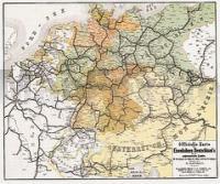
 | Eisenbahnen Deutschlands 1862/63 - Historische Landkarte Nachdruck Planokarte - gerollt von Hartmann, W. - Verlag Rockstuhl |
 | U423 Ylläs Topographische Karte 1:50.000 EUREF-FIN (Maastokarttat) Maanmittauslaitos / Lantmäteriverket Finnland - ProjektNord |
 | 0389-4 BELIANES Topographische Landkarte 1:25.000 Spanien (Grundlage MTN25) Instituto Geográfico Nacional - CNIG Spanien - ProjektNord |
 | Südeifel - Luxembourg 1:50.000 Wanderkarte - GeoMap Von Kyllburg im Norden bis Mettlach im Süden - Von Luxenbourg im Westen bis Trier im Osten |
 | 0457-4 COLLADO HERMOSO Topographische Landkarte 1:25.000 Spanien (Grundlage MTN25) Instituto Geográfico Nacional - CNIG Spanien - ProjektNord |
 | 2353 Gr. Stepenitz Topographische Karte 1:25.000 Messtischblatt des Deutschen Reiches - PreuÃische Landesaufnahme / Reichsamt für Landesaufnahme - Faksimile ProjektNord |
 | 0503 LAS VEGUILLAS Topographische Landkarte 1:50.000 Spanien (Grundlage MTN50) Instituto Geográfico Nacional - CNIG Spanien - ProjektNord |
 | 0456 NAVA DE LA ASUNCIÃN Topographische Landkarte 1:50.000 Spanien (Grundlage MTN50) Instituto Geográfico Nacional - CNIG Spanien - ProjektNord |
 | 3623 08 Ristilampi Topographische Karte 1:20.000 (Maastokartta / Peruskartta / Grundkarta) Maanmittauslaitos / Lantmäteriverket Finnland - ProjektNord |
 | Schwäbische Alb Ost 1:35.000 Auf den Spuren von Staufern und Kelten von Göppingen bis Heidenheim und Ulm 1:35.000, 46 Touren, 500 km - Hikeline Wanderführer Esterbauer |
 | 0287-4 BARBASTRO Topographische Landkarte 1:25.000 Spanien (Grundlage MTN25) Instituto Geográfico Nacional - CNIG Spanien - ProjektNord |
 | 0734-3 VILLARTA DE LOS MONTES Topographische Landkarte 1:25.000 Spanien (Grundlage MTN25) Instituto Geográfico Nacional - CNIG Spanien - ProjektNord |
 | Valsesia 1:25.000 - Wanderkarte (Blatt 101) Riva Valdobbia - Campertogno - Mollia - Rassa - Scopello - Topographische Wanderkarte Valsesia - Riva Valdobbia - Carta escursionistica - Quadrante sud-ovest Geo4 Map - Italien |
 | Kangerlussuaq 1:100.000 Wanderkarte Westgrönland - Vandrekort Vestgrønland Greenland Tourism (Blatt 8) |
| 1325 Kappeln - Gestern und Heute - Historische Ãberlagerung 1878-1880 Topographische Landkarte 1:25.000 im Vergleich - Landesvermessungsamt Schleswig-Holstein / ProjektNord |
 | Heiligkreuzgebirge 1:90.000 Touristische Landkarte Gory Swietokrzyskie Wydawnictwo Pietka - Polen |
 | 1/7 Wanderkarte Naturpark Schlern / Parco Naturale dello Sciliar Naturparke in Südtirol 1:25.000 mit Wandervorschlägen - Casa Editrice Tabacco |
| NJ 36-4 Yozgat Amtliche Topographische Karte der Türkei 1:250.000 NJ 36-4 Yozgat - Müşterek Harekat Haritası HGK |
 | 0972-3 ZÃJAR Topographische Landkarte 1:25.000 Spanien (Grundlage MTN25) Instituto Geográfico Nacional - CNIG Spanien - ProjektNord |
| M-34-38-C/D Lubliniec Amtliche topographische Landkarte Polen 1:50.000 M-34-38-C/D Lubliniec - Mapa Topograficzna Polski Glowny Geodeta Kraju |