| << Deutschland: Historische Karten und Stadtpläne (im Bereich der heutigen Bundesrepublik) << Rockstuhl |
||
|
||

Zuletzt angesehene Artikel:
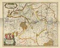
 | Das Fürstentum Anhalt und das Erzbistum Magdeburg 1647 - Historische Landkarte Nachdruck Planokarte - gerollt von Janssonius, Joh. - Verlag Rockstuhl |
 | 0986-1 SANTA JULIANA Topographische Landkarte 1:25.000 Spanien (Grundlage MTN25) Instituto Geográfico Nacional - CNIG Spanien - ProjektNord |
 | 0920-2 SAN NICOLÃS DEL PUERTO Topographische Landkarte 1:25.000 Spanien (Grundlage MTN25) Instituto Geográfico Nacional - CNIG Spanien - ProjektNord |
 | 971-3 VILLANUEVA DE LAS TORRES Amtliche topographische Landkarte 1:25.000 Spanien (M.T.N.) 971-3 Mapa Topográfico Nacional de Espana (MTN25) Instituto Geográfico Nacional - CNIG Spanien |
 | Wandern in den Karpaten 1 - Vom Bulea-See zum Gipfel des Vanatoarea lui Buteanu Herausgegeben von Bernd Schumacher - Schiller Verlag - Rumänien |
 | 142 Topographische Landkarte Wanderkarte und Fahrradkarte Portugal 1:25.000 142 Mapa topográfico - Mapa de caminhadas - Portugal 1:25.000 ProjektNord |
 | 0946-1 SANTIAGO DE CALATRAVA Topographische Landkarte 1:25.000 Spanien (Grundlage MTN25) Instituto Geográfico Nacional - CNIG Spanien - ProjektNord |
 | 3914 06 Rodjanoaivi Topographische Karte 1:20.000 (Maastokartta / Peruskartta / Grundkarta) Maanmittauslaitos / Lantmäteriverket Finnland - ProjektNord |
 | 1834 01 Ruossakero Topographische Karte 1:20.000 (Maastokartta / Peruskartta / Grundkarta) Maanmittauslaitos / Lantmäteriverket Finnland - ProjektNord |
 | 0492 SEGURA DE LOS BAÃOS Topographische Landkarte 1:50.000 Spanien (Grundlage MTN50) Instituto Geográfico Nacional - CNIG Spanien - ProjektNord |
 | 176-1 EMBÃN Amtliche topographische Landkarte 1:25.000 Spanien (M.T.N.) 176-1 Mapa Topográfico Nacional de Espana (MTN25) Instituto Geográfico Nacional - CNIG Spanien |
 | 3044 03 Hurttala Topographische Karte 1:20.000 (Maastokartta / Peruskartta / Grundkarta) Maanmittauslaitos / Lantmäteriverket Finnland - ProjektNord |
 | 3621 11 Saari-Joutsisel Topographische Karte 1:20.000 (Maastokartta / Peruskartta / Grundkarta) Maanmittauslaitos / Lantmäteriverket Finnland - ProjektNord |
 | 833-1 EL TORILEJO Amtliche topographische Landkarte 1:25.000 Spanien (M.T.N.) 833-1 Mapa Topográfico Nacional de Espana (MTN25) Instituto Geográfico Nacional - CNIG Spanien |
 | NL 33-02-21 West (4221-West) Knittelfeld Ãsterreichische Karte 1:25.000 mit Wegmarkierungen (topographische Wanderkarte - UTM) - BEV - Ãsterreich - VergröÃerung (ÃK25V) |
 | 370-1 VEZDEMARBÃN Amtliche topographische Landkarte 1:25.000 Spanien (M.T.N.) 370-1 Mapa Topográfico Nacional de Espana (MTN25) Instituto Geográfico Nacional - CNIG Spanien |
 | 860-3 CONQUISTA Amtliche topographische Landkarte 1:25.000 Spanien (M.T.N.) 860-3 Mapa Topográfico Nacional de Espana (MTN25) Instituto Geográfico Nacional - CNIG Spanien |
| Krebsdorf (Rakutowo) Topographische Karte 1:25.000 Messtischblatt des Deutschen Reiches - PreuÃische Landesaufnahme / Reichsamt für Landesaufnahme - Faksimile ProjektNord |
 | 5202 Aachen - Wanderkarte mit Wanderwegen (geplottete Ausgabe) ProjektNord - Grundlage Amtliche topographische Karte 1:25.000 Landesvermessungsamt Nordrhein-Westfalen |
 | 195-4 SANTA CRISTINA DE VALMADRIGAL Amtliche topographische Landkarte 1:25.000 Spanien (M.T.N.) 195-4 Mapa Topográfico Nacional de Espana (MTN25) Instituto Geográfico Nacional - CNIG Spanien |