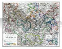
| << Deutschland: Historische Karten und Stadtpläne (im Bereich der heutigen Bundesrepublik) << Rockstuhl << Reisen allgemein: Eisenbahn |
  | |
Zuletzt angesehene Artikel:
![]() | Übersichts-Karte von Thüringen, 1864 - Historische Landkarte Nachdruck - von Ludwig Ravenstein - Planokarte - gerollt - Verlag Rockstuhl |
![]() | 586 Amorosa (Silves) Topographische Landkarte Portugal 1:25.000 Carta Militar de Portugal - Série M888 Instituto Geográfico do Exército (IGeoE) - Portugal |
![]() | 966 Montilla Amtliche topographische Landkarte 1:50.000 Spanien (M.T.N.) 966 Mapa Topográfico Nacional de Espana (MTN50) Instituto Geográfico Nacional - CNIG Spanien |
![]() | 2441 08 Raahe Topographische Karte 1:20.000 (Maastokartta / Peruskartta / Grundkarta) Maanmittauslaitos / Lantmäteriverket Finnland - ProjektNord |
![]() | 4312 08 Panjavaara Topographische Karte 1:20.000 (Maastokartta / Peruskartta / Grundkarta) Maanmittauslaitos / Lantmäteriverket Finnland - ProjektNord |
![]() | 9-A Topographische Landkarte Wanderkarte und Fahrradkarte Portugal 1:25.000 009A Mapa topográfico - Mapa de caminhadas - Portugal 1:25.000 ProjektNord |
![]() | PASSO DELLO SPLUGA (Madesimo - Val di Lei) 1:25.000 - Wanderkarte (Blatt 313) - Topographische Wanderkarte Piemont und Lombardei - Italien C.E. n.313 PASSO DELLO SPLUGA (Madesimo - Val di Lei) - HIKING MAPS Geo4map - PIEMONTE E LOMBARDIA 1:25.000 Geo4 Map - Italien |
![]() | 700-2 (80-53) SON CERVERA (Mallorca) Amtliche topographische Landkarte 1:25.000 Spanien (M.T.N.) 700-2 Mapa Topográfico Nacional de Espana (MTN25) Instituto Geográfico Nacional - CNIG Spanien |
![]() | Gorges du Tarn, Jonte & Causses à pied + VTT - Languedoc-Roussillon Wanderführer - Mountainbikeführer (französisch) Gorges du Tarn, Jonte & Causses à pied + VTT - Languedoc-Roussillon - Balades à pied Chamina - Frankreich |
![]() | Kanu Kompakt Weser Die Weser von Hannoversch Münden nach Minden, mit topografischen Wasserwanderkarten. Mit topografischen Wasserwanderkarten von Erhard Jübermann. Text. v. Schorr, Stefan. Illustration: Hillmann, Carola - Thomas-Kettler-Verlag |
![]() | 1241 06 Rangsby Topographische Karte 1:20.000 (Maastokartta / Peruskartta / Grundkarta) Maanmittauslaitos / Lantmäteriverket Finnland - ProjektNord |
![]() | 613-4 TORRIJAS Amtliche topographische Landkarte 1:25.000 Spanien (M.T.N.) 613-4 Mapa Topográfico Nacional de Espana (MTN25) Instituto Geográfico Nacional - CNIG Spanien |
![]() | 1061 (11-45) Cádiz Amtliche topographische Landkarte 1:50.000 Spanien (M.T.N.) 1061 Mapa Topográfico Nacional de Espana (MTN50) Instituto Geográfico Nacional - CNIG Spanien |
![]() | K07 Bissingen - Reimlingen - Ederheim - Möttingen - Amerdingen - Forheim - Mönchsdeggingen ATK25 Topographische Karte 1:25.000 (Atkis) Bayern Landesvermessungsamt Bayern - Wanderkarte |
![]() | Naturpark Maas-Schwalm-Nette Mitte Topographische Wanderkarte Nordrhein-Westfalen mit Wanderwegen und Radwegen 1:25.000 - ProjektNord |
![]() | 24 Oldenburg in Holstein - Varendorfsche Karte 1789-1792 Topographisch Militärische Charte des Herzogtums Holstein - Reproduktion 1:25.000 |
![]() | Arzachena *** SCHNÄPPCHEN *** Topographische Wanderkarte Sardinien 1:30.000 (deu./engl./frz./ital.) Carta turistico-escursionistica di Arzachena Edizioni Abies |
![]() | Algonquin Park & Ontario Südost 1:220.000 / 1:600.000 (wasserfest) - Landkarte ITMB International Travel Maps (engl.) Algonquin Park & Ontario Southeast |
![]() | 82 Topographische Landkarte Wanderkarte und Fahrradkarte Portugal 1:25.000 082 Mapa topográfico - Mapa de caminhadas - Portugal 1:25.000 ProjektNord |
![]() | W218 Heilbronn 1:25.000 Waldenburger Berge, Öhringen - Karte des Schwäbischen Albvereins - Landesamt für Geoinformation und Landentwicklung Baden-Württemberg (LGL) |


