Willkommen bei MapFox
+++ Buchhändleranfragen willkommen! Tel. 0431-666 75 99 +++
Warenkorb
Artikel: 0 - € 0.00
Zur Kasse
Impressum Kontakt Versandkosten AGB
Leonidio & Kyparissi climbing guide (engl.) Terrain - Griechenland
<< Terrain Cartography (Terrain Maps) - Griechenland
 
Cover

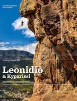
Leonidio has become a major climbing area known for well-bolted single pitches and fully bolted, long multi-pitch routes on excellent limestone. Further south, the beautiful seaside village of Kyparissi now has nearly 400 well-protected routes and unlimited tufas.

This essential guide includes 83 crags (51 in the book, 32 extra in the app) and nearly 2500 sport routes for all levels. Developments up to December 2020 are featured, including new crags Geraki Wave, Loupas, Theatro, Yellow Eyes, and Arcadia.

Bonus: Also included are the new crags at Agios Petros and Agios Andreas, two picturesque villages north of Leonidio with perfect rock and unspoilt nature.

Features

  • Pages: 496
  • 83 crags (51 in the book, 32 extra in the app) and nearly 2500 sport routes for all levels
  • GPS coordinates for each sector
  • Large, clear, accurate photo topos
  • Ample drone photos for easy wayfinding
  • User-friendly layout and info about shade, orientation, kid-friendliness, equippers, and essential gear
  • Hundreds of full-color action photos
  • Stories about local life, history, and people
  • Free app by Vertical-Life. Two books in one!

The proceeds of this guidebook go back into local climbing and crag maintenance. The Municipality of Leonidio has committed to using all profits from the sale of this guidebook to fund further development and crag/route maintenance. Importantly, this ensures that the local authorities will have an ongoing stream of revenue to use for climbing-a low-impact form of tourism which has already added immense value to Leonidio.

Kartenbeispiel

Leonidio & Kyparissi climbing guide (engl.) Terrain - Griechenland
EAN / ISBN: 9786180025026
Preis: EUR 56.90

Bestellartikel: versandfertig in ca. 3-7 Tagen. Dieser Artikel wird speziell für Sie bestellt. Keine Rücknahme!
Produkt EUR Anzahl Bestellen
Leonidio & Kyparissi climbing guide (engl.) Terrain - Griechenland 56.90
Versandkostenfrei in Deutschland

incl. MwSt.

Stichworte, die bei der Suche nützlich sein könnten:
Kyparissi Kletterführer - Leonidio Kletterführer - Griechische Inseln Wanderkarten - Griechenland Trekkingkarten - Terrain Maps - TerrainMaps

Zuletzt angesehene Artikel:

CoverLeonidio & Kyparissi climbing guide (engl.) Terrain - Griechenland

Cover1003 Utrera Amtliche topographische Landkarte 1:50.000 Spanien (M.T.N.)
1003 Mapa Topográfico Nacional de Espana (MTN50) Instituto Geográfico Nacional - CNIG Spanien

Cover609 Sagres (Vila do Bispo) Topographische Landkarte Portugal 1:25.000 Carta Militar de Portugal - Série M888 Instituto Geográfico do Exército (IGeoE) - Portugal

Cover6838 Regenstauf Topographische Landkarte Bayern 1:25.000 - Normalausgabe - ProjektNord (geplottete Ausgabe) - Grundlage amtliche Topographische Karte Bayern DTK25

Cover100-2 DEGAÑA Amtliche topographische Landkarte 1:25.000 Spanien (M.T.N.)
100-2 Mapa Topográfico Nacional de Espana (MTN25) Instituto Geográfico Nacional - CNIG Spanien

CoverANWB Kleine Campingplätze in Europa 2022 *** SCHNÄPPCHEN *** Campingführer
Kleine campings - ANWB Campinggids ANWB

Cover485 - Topographische Landkarte Portugal 1:25.000 Carta Militar de Portugal - Série M888 Instituto Geográfico do Exército (IGeoE) - Portugal

CoverJersey & Guernsey 1:18.000 Straßenkarte ITMB International Travel Maps

CoverAlytus-Region (Süd-Litauen) Touristische Landkarte 1:120.000
Dzukija - Briedis - Litauen

CoverAsia Southeast planning map Planungskarte (engl.) Lonely Planet

Cover5902 Dasburg - Wanderkarte mit Wanderwegen (geplottete Ausgabe) ProjektNord - Grundlage Amtliche topographische Karte Landesamt für Vermessung und Geobasisinformation Rheinland-Pfalz

Cover2311-I Marstal - mit Wanderwegen und Fahrradrouten Topographische Fahrradkarte und Wanderkarte Dänemark 1:50.000 - Kort & Matrikelstyrelsen ProjektNord
2311-I Marstal - Topografisk Cykel- og Vandrekort Danmark

Noch kein Cover vorhandenFlorida Bundesstaaten-Straßenkarte (Florida - USA)
Florida state map

CoverC7130 Weißenburg in Bayern Topographische Karte 1:100.000 - ProjektNord - Kartographie Bayrisches Landesvermessungsamt

CoverAisne Sud à VTT - vol. 2 - Nord / Picardie / Champagne Wanderführer - Mountainbikeführer (französisch)
Aisne Sud à VTT - vol. 2 - Nord / Picardie / Champagne - Itinéraires VTT & vélo - carto-guide: fiches+livret pratique Chamina - Frankreich

CoverMünsterland *** SCHNÄPPCHEN *** ADFC-Regionalkarte 1:75.000 BVA Bielefelder Verlag

Noch kein Cover vorhanden3344-SO Topographische Karte 1:10.000 - Landesvermessungsamt Brandenburg

Cover909 Nerpio Amtliche topographische Landkarte 1:50.000 Spanien (M.T.N.)
909 Mapa Topográfico Nacional de Espana (MTN50) Instituto Geográfico Nacional - CNIG Spanien

CoverU5413 Ulmakuusikko Topographische Karte 1:25.000 EUREF (Peruskartta) Maanmittauslaitos / Lantmäteriverket Finnland - ProjektNord

Cover394 - Topographische Landkarte Portugal 1:25.000 Carta Militar de Portugal - Série M888 Instituto Geográfico do Exército (IGeoE) - Portugal