| << Polen: Wassersportkarten und WassersportfĂĽhrer << Polen: Pommern, OstseekĂĽste << Polen: Wanderkarten: Pommern, OstseekĂĽste << EKO-MAP Polen |
||
|
||
Zuletzt angesehene Artikel:
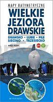
 | GroĂźes Dramburger Seengebiet - Dratzigsee - Lubie - Zetzin See - Streitzig See 1:10.000/1:25.000 Touristische Landkarte, Wassersportkarte mit Tiefenprofilen - Polen Wielkie Jeziora Drawskie - Drawsko, Lubie, Pile, Siecino, Trzesiecko - mapy batymetryczne - GPS 3D - EKO-MAP |
 | Oberländische Seenplatte 1:50.000 Laminierte topographische Wanderkarte Polen Pojezierze Iławskie - Dorzecze Drwęcy - Wzgorza Dylewskie - Kanały Iławski i Elbląski - mapa turystyczna Compass - Polen |
 | 5624 Bad BrĂĽckenau Topographische Landkarte Bayern 1:25.000 - Normalausgabe - ProjektNord (geplottete Ausgabe) - Grundlage amtliche Topographische Karte Bayern DTK25 |
 | FĂĽrstentĂĽmer Schwarzburg und Reuss 1864 - Historische Landkarte Nachdruck Planokarte - gerollt - Bearbeitet von C. Graf - Situation und Schrift von H. Szene. Terrain gezeichnet und grav. von V. Geyer - Verlag Rockstuhl |
 | 777-1 LA GARROVILLA Amtliche topographische Landkarte 1:25.000 Spanien (M.T.N.) 777-1 Mapa Topográfico Nacional de Espana (MTN25) Instituto Geográfico Nacional - CNIG Spanien |
 | 4655/56 Rothenburg/OL Nieder-Neundorf - Geologische Karte 1:25.000 (GK25) Grundlage Messtischblatttopographie Sächsisches Landesamt für Umwelt, Landwirtschaft und Geologie |
 | 9 Kalmar 1:50.000 (wasserfest) *** SCHNĂ„PPCHEN *** Topographische Wanderkarte - Sverigeserien Topo50 - Schweden Norstedts |
 | 4421 07 Luvanjärvi Topographische Karte 1:20.000 (Maastokartta / Peruskartta / Grundkarta) Maanmittauslaitos / Lantmäteriverket Finnland - ProjektNord |
 | 14 Halmstad 1:50.000 (wasserfest) *** SCHNĂ„PPCHEN *** Topographische Wanderkarte - Sverigeserien Topo50 - Schweden Norstedts |
 | 386-III Penalba Amtliche topographische Landkarte 1:25.000 Spanien (M.T.N.) 386-III Mapa Topográfico Nacional de Espana (MTN25) Instituto Geográfico Nacional - CNIG Spanien |
 | Plan-Mappe Nr. 4: Kreis Viersen Stadtplan von Stadt Duisburg, Stadt Krefeld, Brüggen, Grefrath, Kempen, Nettetal, Niederkrüchten, Schwalmtal, Tönisvorst, Viersen, Willich und Kreiskarte Blees-Verlag |
| 1406-31 Plauen-W - Geologische Karte 1:25.000 (GK25) Grundlage Topographische Karte Ausgabe Volkswirtschaft Sächsisches Landesamt für Umwelt, Landwirtschaft und Geologie |
 | 884 La Carolina Amtliche topographische Landkarte 1:50.000 Spanien (M.T.N.) 884 Mapa Topográfico Nacional de Espana (MTN50) Instituto Geográfico Nacional - CNIG Spanien |
| 5542 Johanngeorgenstadt (146) - Geologische Karte 1:25.000 (GK25) Grundlage Vollbornsche Äquidistantenkarte Sächsisches Landesamt für Umwelt, Landwirtschaft und Geologie |
 | 58 Köping 1:50.000 (wasserfest) *** SCHNÄPPCHEN *** Topographische Wanderkarte - Sverigeserien Topo50 - Schweden Norstedts |
 | Naturpark Barnim, Wandlitzer See und Umgebung - Radwander- und Wanderkarte 1:35.000 (Nr. 090) Ausflüge zwischen Oranienburg, Biesenthal, Wandlitz und Bernau. Radwander- und Wanderkarte. 1:35000, Radtourenvorschläge mit Entfernungsangaben. Viele Tipps zu Sehenswürdigkeiten. GPS-fähig. Mit QR-Code Dr. Barthel Verlag |
 | Schmalkalden und Umgebung (Blatt 9) *** SCHNĂ„PPCHEN *** Topographische Wanderkarte ThĂĽringen 1:25.000 - ThĂĽringer Landesvermessungsamt - Wanderkarte mit Wanderwegen |