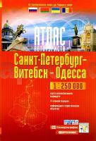
| << Moldawien << Russland << Weißrussland (Belarus) << Ukraine << Kartografija Kiev - ukrmap Ukraine |
  | |
Zuletzt angesehene Artikel:
![]() | Touristischer Autoatlas von der Ostsee bis zum Schwarzen Meer - Straßenatlas - 1:250.000 (ukrainisch - kyrillische Schrift) Atlas awtoturista - Sankt Petersburg - Witebsk - Odessa - Ot Baltijskogo Morija Do Tschernogo Morija Kartografija - ukrmap Ukraine - Belkartografija - Ingeocad - Nowgorod |
![]() | 263.31 Amtliche topographische Karte 1:25.000 Polen |
![]() | 55 Schneidemühl - Karte des Deutschen Reiches 1:100.000 (KDR 100 GB) - Großblatt Reichsamt für Landesaufnahme / Preußische Landesaufnahme ProjektNord |
![]() | 451 Ledesma Amtliche topographische Landkarte 1:50.000 Spanien (M.T.N.) 451 Mapa Topográfico Nacional de Espana (MTN50) Instituto Geográfico Nacional - CNIG Spanien |
![]() | 17 Alte Valli di Lanzo - Val Grande - Val d´Ala - Val di Viù 1:25.000 Topographische Wanderkarte l`Escursionista Editore - Italien |
![]() | T523 Kursu Topographische Karte 1:50.000 EUREF-FIN (Maastokarttat) Maanmittauslaitos / Lantmäteriverket Finnland - ProjektNord |
![]() | NL 33-01-09 Ost (3209-Ost) Bad Reichenhall Österreichische Karte 1:25.000 mit Wegmarkierungen (topographische Wanderkarte - UTM) - BEV - Österreich - Vergrößerung (ÖK25V) |
![]() | 5323 Schlitz Topographische Landkarte Hessen 1:25.000 - ProjektNord (geplottete Ausgabe) |
![]() | L-34-14-B Pilisvörösvar Amtliche Topographische Karte Ungarn 1:50.000 |
![]() | Von Küste zu Küste - Westlicher Teil 1:25.000 - Calazo Outdoormaps Serie - Calazo Förlag Dänemark Kyst till Kyst stien - Vest Calazo Förlag Dänemark |
![]() | British Columbia Straßenkarte 1:1.3 Mio. (British Columbia - Kanada) British Columbia road map Pathfinder Maps (GM Johnson) |
![]() | 4414 01 Mertajärvi Topographische Karte 1:20.000 (Maastokartta / Peruskartta / Grundkarta) Maanmittauslaitos / Lantmäteriverket Finnland - ProjektNord |
![]() | Pindos Süd: Tzoumerka - Peristeri - Koziakas - Avgo - Topographische Bergwanderkarte Griechenland 1:50.000 (Blatt 3.2 / 4.2) - Thessaly Notia Πινδος: Τζουμερκα - Περιστερι - Κοζιακας - Αυγο Anavasi - Griechenland |
![]() | 1522 Hollingstedt - Gestern und Heute - Historische Überlagerung 1902-1930 Topographische Landkarte 1:25.000 im Vergleich - Landesvermessungsamt Schleswig-Holstein / ProjektNord |
![]() | 2778 Lissewo Topographische Karte 1:25.000 Messtischblatt des Deutschen Reiches - Preußische Landesaufnahme / Reichsamt für Landesaufnahme - Faksimile ProjektNord |


