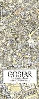
| << Deutschland: Bildstadtpläne und Panoramastadtpläne << Bollmann-Bildkarten-Verlag (Bild-Stadtpläne) |
  | |
Zuletzt angesehene Artikel:
![]() | Goslar 2002 1:2.800/1:20.000 (Blatt 310) Bildstadtplan Bollmann-Bildkarten-Verlag |
![]() | Guadeloupe & Dominica Travel Reference Map 1:110.000 / 50.000 (engl.) Guadeloupe & Dominica ITMB International Travel Maps (engl.) |
![]() | 4047 Golßen Sonderausgabe mit Wanderwegen - Topographische Wanderkarte Brandenburg 1:25.000 ProjektNord |
![]() | 10011 Gjerstad Topographische Landkarte 1:50.000 Norge-serien - Nordeca Norwegen |
![]() | 62 Altona - Hamburg - Harburg - Varendorfsche Karte 1789-1792 Topographisch Militärische Charte des Herzogtums Holstein - Reproduktion 1:25.000 |
![]() | Glatz und Glatzer Kessel Stadtplan 1:8.000 + Touristische Landkarte 1:50.000 Wanderkarte, Radwanderkarte, Freizeitkarte, Wintersportkarte Kłodzko Kotlina Kłodzka mapa PLAN Galileos - Polen |
![]() | 10021 Store Le Topographische Landkarte 1:50.000 Norge-serien - Nordeca Norwegen |
![]() | 6414 Grünstadt West Topographische Karte 1:25.000 - Landesamt für Vermessung und Geobasisinformation Rheinland-Pfalz |
![]() | 306 Kythira 1:50.000 Landkarte Griechische Inseln Kythera Road Editions - Griechenland |
![]() | Cento Colli 1:50.000 (Blatt V123) Touristische Wanderkarte Italien - Belletti Editore |
![]() | Katalonien - Aragon - Andorra Straßenkarte 1:400.000 (Blatt 574) Aragon - Catalunya - Andorra Michelin Regional |
![]() | 184.21 Gorlice Amtliche topographische Karte 1:25.000 Polen |
![]() | Amorgos (Blatt 306) Landkarte Griechische Inseln 1:65.000 Orama - Griechenland Αμοργός |
![]() | 46 GALWAY Wanderkarte Irland 1:50.000 DISCOVERY MAP - Ordnance Survey |
![]() | 33-c Topographische Landkarte Georgien 1:50.000 Geoland Maps Georgien |
![]() | Riviera di Levante - Cartoguida cicloturistica 1:50.000 (RL / CG-LR) Golfo del Tigullio, Val Fontanabuona, Val Graveglia e Val Petrino - Radwanderkarte EdM - Edizioni del Magistero - Italien |
![]() | GreenVelo: Woiwodschaft Karpatenvorland 1:100.000 Radwanderkarte der Radwege - Steinpapier Województwo podkarpackie GreenVelo mapa tras rowerowych (papier skalny) Europilot - Daunpol - Polen |
![]() | Region Halle - Leipzig 1:200.000 Topographische Straßenkarte ProjektNord - Bundesamt f. Kartographie u. Geodäsie |
![]() | 342 Rhodos 1:75.000 Landkarte Griechische Inseln -Terrain Cartography - Griechenland (wasserfest und reissfest) Terrain maps |
![]() | 322 Wetterstein - Karwendel - Seefeld - Leutasch - Garmisch Partenkirchen 1:50.000 - Wanderkarte / Radwanderkarte / Wintersportkarte Österreich - GPS - Freytag & Berndt |


