| << Cookinseln - Tokelau-Inseln - Niue - Kermadecinseln |
||
|
||
Zuletzt angesehene Artikel:
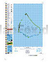
 | PI10 Manihiki (Cookinseln) Topographische Landkarte 1:25.000 - Land Information New Zealand |
 | 183 S Lyngen SÃR 1:50.000 - Amtliche Topographische Landkarte Norwegen - Startens Kartverk |
 | Wingst Topographische Wanderkarte mit Wanderwegen und Radwegen 1:25.000 Niedersachsen - ProjektNord |
| 3014SB Révigny-sur-Ornain - GPS Amtliche Topographische Wanderkarte Frankreich 1:25.000 - série bleue (IGN) |
 | Peking - Spaziergänge (englisch) Das Kulturerbe erforschen. Beijing Walks - Exploring the Heritage Odyssey Publications |
 | Cabo de Gata - Nijar - Mit Almeria & Mojacar Reiseführer - von Ulrike Wiebrecht - via reise |
 | Corsica walking guide - 25 mountain and coastal day walks - Wanderführer Frankreich - Cicerone (englisch) |
| 7513 Offenburg Topographische Landkarte 1:25.000 - Landesvermessungsamt Baden-Württemberg |
 | Odessa 1:20.000 Stadtplan (kyrillisch) Odessa Kartografija - ukrmap Ukraine |
 | 187 Dorking - Reigate & Crawley area - Wanderkarte GroÃbritannien 1:50.000 LANDRANGER MAP - Ordnance Survey |
 | 100% Cityguide Hongkong Reiseführer inkl. App + Extra Stadtplan - von Annemarelle van Schayik - Mo Media |
 | 5507 Montafon 1:35.000 - Wanderkarte Ãsterreich - GPS - Freytag & Berndt |
 | Schweriner See Rad-, Wander- und Gewässerkarte 1:35.000 - Grünes Herz |
 | Unteres Warnowland Rad- und Wanderkarte 1:30.000 - Grünes Herz |
 | Tansania 1:1.3 Mio. (wasserfest) Landkarte - ITMB International Travel Maps (engl.) Tanzania |
 | Loiret Randonnée (Blatt 3) 1:50.000 Jargeau - Bellegarde Plein-Air Wanderkarte Frankreich - IGN Frankreich |
 | NR754 Chitwan - Chepang Hills Trail - Trekkingkarte 1:50.000 Himalayan MapHouse - Nepal Chitwan - Chepang Hills Trail |
 | T-05: Rovinj - Istrien 1:30.000 Topographische Wanderkarte - Mateus Cartography - Kroatien |
 | South Australia state StraÃenkarte 1:1.8 Mio. - Australien HEMA maps Australien |
 | Weststeirischer Jakobsweg - Wanderführer von Reinhard Dippelreither - Outdoor-Führer Conrad-Stein-Verlag |