| << Cookinseln - Tokelau-Inseln - Niue - Kermadecinseln |
||
|
||
Zuletzt angesehene Artikel:
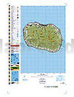
 | PI12 Rarotonga (Cookinseln) Topographische Landkarte 1:25.000 - Land Information New Zealand |
 | Myrhorod Stadtplan 1:13.000 Kartografija - ukrmap Ukraine |
 | Pistes du Maroc - Le Sahara Atlantique Guide J. Gandini - Serre Editeur |
 | Albsteig (HW1) - Albsüdrandweg (HW2) Wanderführer - von Markus Rauschenberger - Conrad Stein Verlag GmbH |
 | KulturSchock Spanien KulturSchock Reise-Know-How Verlag |
 | Reiseatlas Südafrika 1:1.5 Mio. Namibia - Botsuana - Kunth Verlag |
 | Kuba 1:1.5 Mio. Wandkarte National Geographic Cuba flat map |
 | Tokyo mit Yokohama CityTrip PLUS - Stadtführer Reise-Know-How Verlag |
 | Italy`s Grande Traversata delle Alpi Wanderführer - Cicerone (englisch) |
 | 16 MARCO POLO Freizeitkarte Rhein, Ruhr 1:110.000 wasserfest, reißfest |
 | Österreich - politisch Larsen-Puzzle K41 (70 Teile) |
 | Neuseeland Reisehandbuch - Iwanowski´s Reisebuchverlag |
 | Essen 1969 (Blatt 89) Historischer Bildstadtplan Bollmann-Bildkarten-Verlag |
 | Poltawa Stadtplan 1:17.000 Poltava Kartografija - ukrmap Ukraine |
 | Tschechien - Slowakei Straßenkarte 1:600.000 (Blatt 731) Michelin |
 | Monte Morello 1:25.000 (MOR) - Wanderkarte Italien - D.R.E.A.M. Italia |
 | Andalucia Coastal Walks Wanderführer - Cicerone (englisch) |
 | Marokko / Morocco 1:1 Mio. Landkarte Reise-Know-How Verlag - world mapping project |
| Bridge Glacier - TOPO (Blatt VCBC40) Topographische Landkarte - Backroad Topo Map Kanada |
 | Sizilien 1:200.000 Landkarte Reise-Know-How Verlag - world mapping project |