| << Österreich: Amtliche topographische Wanderkarten des BEV 1:25.000 (Vergrößerungen - UTM-Gitter) |
  | |
|
||
Zuletzt angesehene Artikel:
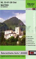
![]() | NL 33-01-26 Ost (3226-Ost) Matrei in Osttirol Österreichische Karte 1:25.000 mit Wegmarkierungen (topographische Wanderkarte - UTM) - BEV - Österreich - Vergrößerung (ÖK25V) |
![]() | 2451 Stolzenburg Topographische Karte 1:25.000 Messtischblatt des Deutschen Reiches - Preußische Landesaufnahme / Reichsamt für Landesaufnahme - Faksimile ProjektNord |
![]() | 5167 Jordansmühl Topographische Karte 1:25.000 Messtischblatt des Deutschen Reiches - Preußische Landesaufnahme / Reichsamt für Landesaufnahme - Faksimile ProjektNord |
![]() | 1132 05 KYLMÄ-PIHLAVA Topographische Karte 1:20.000 (Maastokartta / Peruskartta / Grundkarta) Maanmittauslaitos / Lantmäteriverket Finnland - ProjektNord |
![]() | 15H SV HUDIKSVALL (S) 1:50.000 *** SCHNÄPPCHEN *** Topographische Wanderkarte Schweden (Terrängkarta/Gröna Kartan) - Kartförlaget - Lantmäteriet Landkarte Schweden |
![]() | 4651 Königswartha-Wittichenau (22) - Geologische Karte 1:25.000 (GK25) Grundlage Vollbornsche Äquidistantenkarte Sächsisches Landesamt für Umwelt, Landwirtschaft und Geologie |
![]() | 4313 Welver - Wanderkarte mit Wanderwegen (geplottete Ausgabe) ProjektNord - Grundlage Amtliche topographische Karte 1:25.000 Landesvermessungsamt Nordrhein-Westfalen |
![]() | 3113 12 Toikkala Topographische Karte 1:20.000 (Maastokartta / Peruskartta / Grundkarta) Maanmittauslaitos / Lantmäteriverket Finnland - ProjektNord |
![]() | Monts de Lacaune à pied + VTT - Haut-Languedoc Wanderführer - Mountainbikeführer (französisch) Monts de Lacaune à pied + VTT - Haut-Languedoc - Balades à pied Chamina - Frankreich |
![]() | NL 33-05-03 West (4103-West) Bad Sankt Leonhard im Lavanttal Österreichische Karte 1:25.000 mit Wegmarkierungen (topographische Wanderkarte - UTM) - BEV - Österreich - Vergrößerung (ÖK25V) |
![]() | 8335 Lenggries Topographische Landkarte Bayern 1:25.000 - Normalausgabe - ProjektNord (geplottete Ausgabe) - Grundlage amtliche Topographische Karte Bayern DTK25 |
![]() | 5211 Weyerbusch - Wanderkarte mit Wanderwegen (geplottete Ausgabe) ProjektNord - Grundlage Amtliche topographische Karte 1:25.000 Landesvermessungsamt Nordrhein-Westfalen |
![]() | 1012 03+15 Eckerö Topographische Karte 1:20.000 (Maastokartta / Peruskartta / Grundkarta) Maanmittauslaitos / Lantmäteriverket Finnland - ProjektNord |
![]() | 6933 Thalmässing Topographische Landkarte Bayern 1:25.000 - Normalausgabe - ProjektNord (geplottete Ausgabe) - Grundlage amtliche Topographische Karte Bayern DTK25 |
![]() | NM 33-11-24 West (4324-West) Herzogenburg Österreichische Karte 1:25.000 mit Wegmarkierungen (topographische Wanderkarte - UTM) - BEV - Österreich - Vergrößerung (ÖK25V) |
![]() | 3733 04 Savukoski Topographische Karte 1:20.000 (Maastokartta / Peruskartta / Grundkarta) Maanmittauslaitos / Lantmäteriverket Finnland - ProjektNord |
![]() | Erläuterungen zur Geologischen Karte 4951 Neustadt-Hohwald (69) - Ausgabe 1889 Sächsisches Landesamt für Umwelt, Landwirtschaft und Geologie |
![]() | 495 Grandola Topographische Landkarte Wanderkarte und Fahrradkarte Portugal 1:25.000 495 Mapa topográfico - Mapa de caminhadas - Portugal 1:25.000 ProjektNord |


