Willkommen bei MapFox
Wurde Ihre Bestellung bestätigt? Wenn nicht - gab es evtl. ein SERVER-Problem! Bitte kontaktieren Sie uns! +++ Buchhändler-Anfragen erwünscht +++
Warenkorb
Artikel: 0 - € 0.00
Zur Kasse
Impressum Kontakt Versandkosten AGB
Western Arabia Terra 1:4 Mio. PLANO Margaritifer Terra & Schiaparelli - Map of Mars - Ordnance Survey
<< Astronomische Karten und Bücher
 
Cover

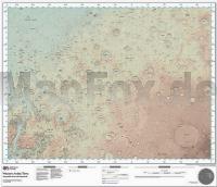
Landkarte des Mars.

This Western Arabia Terra map is a topographical basemap full of our intricate detail for an area on the surface of Mars that`s similar in size to the USA. Showing a 3672x2721km extent (around 3.8m sq miles) of the Martian surface, this map of the Red Planet is OS´ first foray in to intragalactic mapping.

Created by OS Cartographer Chris Wesson using NASA open data and made to a 1:4,000,000 scale, the one-off map was made to see if our style of mapping has potential for future Mars missions.

The easy-to-read map sheet measures 980 by 840mm and is flat so it`s ideal for hanging on a wall or, if you`ve had enough of exploring Earth it`s great for planning Martian adventures during the Summer holidays.

Kartenausschnitt

Kartenbeispiel

Western Arabia Terra 1:4 Mio. PLANO Margaritifer Terra & Schiaparelli - Map of Mars - Ordnance Survey
Preis: EUR 39.95

Bestellartikel: versandfertig in ca. 3-7 Tagen. Dieser Artikel wird speziell für Sie bestellt. Keine Rücknahme!
Produkt EUR Anzahl Bestellen
Western Arabia Terra 1:4 Mio. PLANO Margaritifer Terra & Schiaparelli - Map of Mars - Ordnance Survey 39.95
Versandkostenfrei in Deutschland

incl. MwSt.

Stichworte, die bei der Suche nützlich sein könnten:
Mars Landkarte - Astronomie - Sternkarten - Himmelskarten - Astronomische Bücher - Astronomiebücher

Zuletzt angesehene Artikel:

CoverWestern Arabia Terra 1:4 Mio. PLANO Margaritifer Terra & Schiaparelli - Map of Mars - Ordnance Survey

CoverWandern auf Fontanes Wegen - von Wiebrecht, Ulrike - via reise

CoverSchrammsteine - Affensteine Wanderkarte 1:10.000 - Rolf Böhm Verlag

CoverChina - Mongolei 1:6 Mio.
CHINA - MONGOLIA - World Travel Map - Internationale Landkarte - Cartographia

CoverSteiermark - Kärnten 1:250.000 Auto- und Freizeitkarte - freytag & berndt

Noch kein Cover vorhanden225.22 Fracki Amtliche topographische Karte 1:25.000 Polen

Cover60 Große Skitouren Ostalpen Mit GPS-Daten - von Andrea Strauß und Andreas Strauß - Rother Selection - Bergverlag Rother

CoverGran Trail Aneto - Posets - Laufkarte / Wanderkarte 1:30.000 Prames - Spanien

CoverOrjol (Orel) Stadtplan 1:14.000 - Russland
Orel - Karta Goroda Rus Co. Ltd.

CoverKentucky & Tennessee Whiskey Puzzle 1.000 Teile Format 48 x 68 cm WATER and WINES PUZZLES

CoverPorto minimap Innenstadtplan 1:10.000 laminiert Touristische Landkarte - ExpressMap

CoverDeutsche Nordseeküste - Wohnmobil-Tourguide Die schönsten Routen - von Gaby Gölz - Reise Know-How

Noch kein Cover vorhanden3642-SW Topographische Karte 1:10.000 - Landesvermessungsamt Brandenburg

CoverCalvados - Manche Straßenkarte Local 1:150.000 (Blatt 303) Michelin Frankreich

CoverCindrel Gebirge Wanderkarte 1:75.000 (deutsch / rumänisch)
Muntii Cindrel Constant Verlag Rumänien

CoverPortugal 1:500.000 - Lissabon 1:10.000 Landkarte - ITMB International Travel Reference Maps (engl.)

CoverSerra de Cardó - Terres de l´Ebre 2 Wanderkarten 1:20.000 im Set - Editorial Piolet - Spanien

CoverAppennino Pistoiese 1:25.000 (APi) - Wanderkarte Italien - D.R.E.A.M. Italia

CoverCornwall 1:150.000 Autokarte
Cornualles Cornouailles freytag & berndt

CoverZion & Bryce Canyon national park map Planungskarte (engl.) Lonely Planet