Willkommen bei MapFox
Wurde Ihre Bestellung bestätigt? Wenn nicht - gab es evtl. ein SERVER-Problem! Bitte kontaktieren Sie uns! +++ Buchhändler-Anfragen erwünscht +++
Warenkorb
Artikel: 0 - € 0.00
Zur Kasse
Impressum Kontakt Versandkosten AGB
WORLD-STRESS-MAP 2025 - POSTER gerollt ca. 107 x 53 cm
<< Welt - allgemein
 
Cover

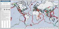
The World Stress Map (WSM) is a global compilation of information on the crustal present-day stress field maintained since 2009 at the GFZ Helmholtz Centre for Geosciences within Section 2.6 Seismic Hazard and Risk Dynamics. It is a collaborative project between academia and industry that aims to characterize the crustal stress pattern and to understand the stress sources. The WSM commenced in 1986 as a project of the International Lithosphere Program (ILP) under the leadership of Mary-Lou Zoback. From 1995-2008 it was a project of the Heidelberg Academy of Sciences and Humanities headed by Karl Fuchs and Friedemann Wenzel. . All stress information is analysed and compiled in a standardized format and quality-ranked for reliability and comparability on a global scale. The latest WSM database release 2025 contains 100,842 data records located in the Earth’s crust. The WSM is an open-access public database and is used by various academic and industrial institutions working in a wide range of Earth science disciplines such as geodynamics, hazard assessment, reservoir geomechanics, and geotechnical applications. The main operational areas are

- Reservoir characterization and management
- Stability of mines, tunnel, boreholes and waste disposal sites
- Calibration of geomechanical-numerical models
- 4D Thermo-Hydro-Mechanical (THM) modelling of stress changes
- Hazard assessment e.g. by means of fault-slip tendency and fracture potential analysis

Kartenbeispiel

WORLD-STRESS-MAP 2025 - POSTER gerollt ca. 107 x 53 cm
Preis: EUR 49.90

sofort versandfertig Dieser Artikel ist im Normalfall sofort lieferbar.
Produkt EUR Anzahl Bestellen
WORLD-STRESS-MAP 2025 - POSTER gerollt ca. 107 x 53 cm 49.90
Versandkostenfrei in Deutschland

incl. MwSt.

Stichworte, die bei der Suche nützlich sein könnten:
Subduktionszonen - Kontinentalplatten - Welt Landkarte - Weltkarte - Plattentektonik - Welt - Erde

Zuletzt angesehene Artikel:

CoverWORLD-STRESS-MAP 2025 - POSTER gerollt ca. 107 x 53 cm

CoverQatar und Doha - Stadtplan mit touristischer Info - Patentfalter Kartographie Huber

Cover01 Arica - Iquique 1:500.000 - Chile Straßenkarte - ProjektNord

CoverWesterwald - Montabaur - Elz Topographische Wanderkarte Rheinland-Pfalz / Hessen mit Wanderwegen und Radwegen 1:25.000 - ProjektNord

CoverSouth West Coast Path 1:25.000 (3): South Cornwall *** SCHNÄPPCHEN *** Wanderkarte Geographers` A-Z Großbritannien

Cover15 Short Walks on the Isle of Wight - von Curtis, Paul - Cicerone Press Limited

CoverGT Süd-Finnland Straßenkarte 1:250 000 Autokarte
GT Tiekartta Etelä-Suomi - GT Road Map Southern Finland Karttakauppa Finnland

Noch kein Cover vorhandenZlatibor 1:7.500 Wanderkarte
Zlatibor térkép Intersistem Kartografija

Cover08 Talca - Concepción - Temuco 1:500.000 - Chile Straßenkarte - ProjektNord

CoverNördlicher Teutoburger Wald - Wanderkarte NRW 1:25.000 Borgholzhausen, Dissen, Halle, Steinhagen, Versmold, Werther - Herausgegeben vom Teutoburger-Wald-Verein - Bonifatius-Verlag

Noch kein Cover vorhandenQeqertarsuaq / Disko Insel / Disko Ø (Blatt 11) 1:250.000 - LAMINIERTE AUSGABE Topographische Landkarte Westgrönland Saga Maps

CoverConnemara Wanderkarte (wasserfest) 1:30.000 *** SCHNÄPPCHEN *** Superwalker - HARVEY MAPS
Connemara Superwalker

CoverFinnland 1:500.000 *** SCHNÄPPCHEN *** Autokarte
Suomi - Finland, Finlande, Finlandia freytag & berndt

CoverNuuksio - Luukki 1:15.000 Wanderkarte / Outdoorkarte
Nuuksio - Luukki Retkeilykartta / Hiking Map Karttakauppa Finnland

CoverLónsöræfi - Snæfell (Blatt 6) *** SCHNÄPPCHEN *** Wanderkarte Island 1:100.000 / 1:50.000 - Sérkort - Mál og menning

Cover15 Short Walks Cheddar and the Mendips - von Mead, Rachel - Cicerone Press Limited

CoverRiesengebirgsvorland (Blatt 62) Podzvičinsko - Königinhof an der Elbe - Horschitz - Kukus - Bad Bielohrad - Petzka - Topographische Wanderkarte 1:25.000 EUROKART
Podkrkonoší - Podzvičinsko - Dvůr Králové nad Labem - Hořice - Kuks - Lázně Bělohrad - Pecka Geodezie On Line - Tschechien

Cover12 Taitao 1:500.000 - Chile Straßenkarte - ProjektNord

Noch kein Cover vorhandenEngland Süd 1:270.000 Landkarte - ITMB International Travel Reference Maps (engl.)
England South

Cover105M13 Mount Haldane - Yukon Territory Topographische Landkarte 1:50.000 - Canada - Yukon