| << Deutschland: Kreiskarten des Deutschen Reiches 1:100.000 |
  | |
|
||
Zuletzt angesehene Artikel:
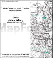
![]() | Johannisburg (Masurische Seen II) Kreiskarte des Deutschen Reiches 1:100.000 (KDR 100 KK) - Faksimile Reichsamt für Landesaufnahme |
![]() | Qaqortoq 1:100.000 Wanderkarte Südgrönland - Vandrekort Sydgrønland Greenland Tourism (Blatt 3) |
![]() | U432 Kierinki Topographische Karte 1:50.000 EUREF-FIN (Maastokarttat) Maanmittauslaitos / Lantmäteriverket Finnland - ProjektNord |
![]() | L2910 Papenburg (geplottete Ausgabe) Topographische Karte 1:50.000 Kartografie Landesvermessungsamt Niedersachsen - ProjektNord |
![]() | 200-3 BURGOS OESTE Amtliche topographische Landkarte 1:25.000 Spanien (M.T.N.) 200-3 Mapa Topográfico Nacional de Espana (MTN25) Instituto Geográfico Nacional - CNIG Spanien |
![]() | 3346 Berlin-Französisch Buchholz Sonderausgabe mit Wanderwegen - Topographische Wanderkarte Brandenburg 1:25.000 ProjektNord |
![]() | 5279 Ollschin Topographische Karte 1:25.000 Messtischblatt des Deutschen Reiches - Preußische Landesaufnahme / Reichsamt für Landesaufnahme - Faksimile ProjektNord |
![]() | Köln Nordost - Bergisch Gladbach Topographische Wanderkarte Nordrhein-Westfalen mit Wanderwegen und Radwegen 1:25.000 - ProjektNord |
![]() | Nordkalotte - Nordkap 1:800.000 *** SCHNÄPPCHEN *** Autokarte Pohjoiskalotti Nordkapp / Nordkalotten Matkailukartta ja Opas - Suomen, Ruotsin ja Norjan pohjoisosan tiekartta Karttakeskus / Genimap |
![]() | 441 - Topographische Landkarte Portugal 1:25.000 Carta Militar de Portugal - Série M888 Instituto Geográfico do Exército (IGeoE) - Portugal |
![]() | 8234 Penzberg Topographische Landkarte Bayern 1:25.000 - Normalausgabe - ProjektNord (geplottete Ausgabe) - Grundlage amtliche Topographische Karte Bayern DTK25 |
![]() | Osterode in Ostpreußen Kreiskarte des Deutschen Reiches 1:100.000 (KDR 100 KK) - Faksimile Reichsamt für Landesaufnahme |
![]() | Bonn - Ville Topographische Wanderkarte Nordrhein-Westfalen mit Wanderwegen und Radwegen 1:25.000 - ProjektNord |
![]() | L2550 Brüssow Topographische Karte 1:50.000 (Regelblattschnitt) Landesvermessungsamt Brandenburg |
![]() | 502 Matilla de los Caños del RÃo Amtliche topographische Landkarte 1:50.000 Spanien (M.T.N.) 502 Mapa Topográfico Nacional de Espana (MTN50) Instituto Geográfico Nacional - CNIG Spanien |
![]() | 8242 Inzell Topographische Landkarte Bayern 1:25.000 - Normalausgabe - ProjektNord (geplottete Ausgabe) - Grundlage amtliche Topographische Karte Bayern DTK25 |
![]() | 3244 Kremmen Sonderausgabe mit Wanderwegen - Topographische Wanderkarte Brandenburg 1:25.000 ProjektNord |
![]() | 2317-IV - mit Wanderwegen und Fahrradrouten Topographische Fahrradkarte und Wanderkarte Dänemark 1:50.000 - Kort & Matrikelstyrelsen ProjektNord 2317-IV - Topografisk Cykel- og Vandrekort Danmark |
![]() | 6139 Falkenberg Topographische Landkarte Bayern 1:25.000 - Normalausgabe - ProjektNord (geplottete Ausgabe) - Grundlage amtliche Topographische Karte Bayern DTK25 |
![]() | 253 - Topographische Landkarte Portugal 1:25.000 Carta Militar de Portugal - Série M888 Instituto Geográfico do Exército (IGeoE) - Portugal |


